Tucked away in the southwest corner of Micronesia, Palau is not just a dot on the map. It is a scattered constellation of 340 coral and volcanic islands resting on the Kyushu-Palau Ridge. If you are looking for the kind of travel where your phone signal dies and your jaw stays dropped, this is it.
The geography here is dramatic. A massive barrier reef system wraps around most of the archipelago like a protective shell. The reef is continuous on the west side but breaks apart on the east. This creates distinct aquatic environments depending on which side of the islands you are exploring.
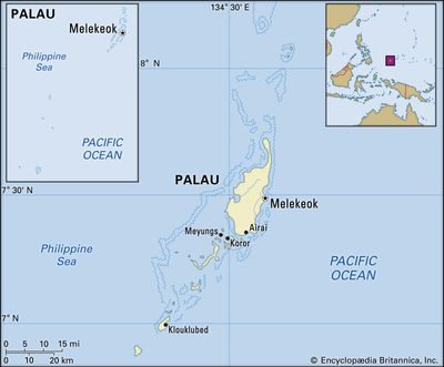
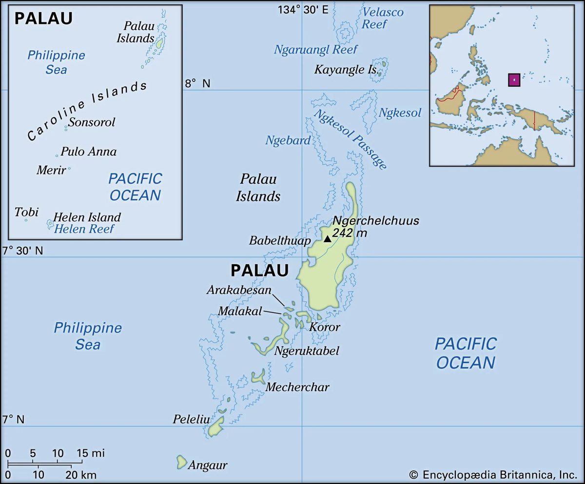
Most travelers will land on one of the major populated hubs. Babelthuap (also spelled Babeldaob) is the largest island. Koror is the commercial heart. Then you have Malakal, Arakabesan, and Peleliu. These are the places where you will find hotels, airports, and the bulk of tourism infrastructure.
But the story gets wild if you look further out.
To the north of Babelthuap lie the sparsely populated Kayangel Islands. They sit quietly above the main action. To the south of Peleliu, you have the raised coral islands of Angaur, Sonsorol, Pulo Anna, and Tobi. These spots sit outside the main barrier reef system. That separation matters. It changes the water chemistry. It changes the marine life. It makes them feel entirely separate from the main cluster.
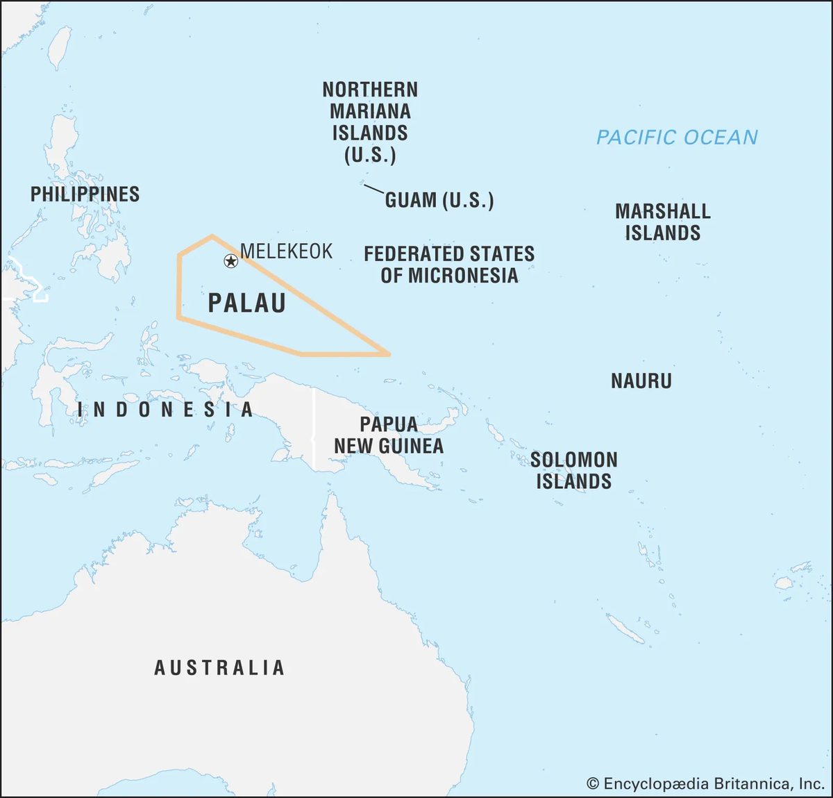
Location-wise, Palau is remote. It sits 830 miles (1,330 km) southwest of Guam. New Guinea is 400 miles (650 km) to the south. The Philippines lie 550 miles (890 km) to the west. You are not close to anything. You are in the middle of the western Pacific.
This isolation is why the ecosystem is so preserved. The barrier reef protects the inner lagoons from rough ocean swells. The volcanic roots of the islands provide hard substrate for coral to latch onto. The result is a marine park that feels untouched by mass tourism.
For the traveler planning a trip, this geography dictates your itinerary. You cannot see it all in a day. You have to choose your entry point. Koror offers the easiest access. Babelthuap offers the most land to explore. The outer islands require boats, permits, and patience.
Most visitors start with the barrier reef system. The west side offers calm, clear waters perfect for snorkeling. The east side is more rugged. The breaks in the reef create channels where currents run strong. This attracts larger pelagic species. Sharks. Rays. Tuna.
If you are looking for where to go in Palau for diving, the answer is usually the reef itself. But if you want what to see in Palau’s outer islands, you are looking at Angaur and Sonsorol. These are not resort destinations. They are historical and ecological treasures.
The distance to the Philippines and Guam might seem like a barrier. It is actually a filter. It keeps the crowds away. It keeps the development low. It ensures that when you finally step off the plane, the air smells like salt and volcanic soil.
Palau is not easy to get to. That
The long road to sovereignty
Palau’s path to independence wasn’t quick. For decades it sat under the UN Trust Territory of the Pacific Islands, a mandate handed to the United States after World War II in 1947. The U.S. administered the islands, but the end of that arrangement was messy.
They tried to dissolve the trusteeship in 1986. It failed.
The core issue was the Compact of Free Association. Washington wanted a deal. Palau wanted to be sure. It took nearly a decade of repeated measures and political maneuvering to get the necessary support. The votes finally clicked into place in 1993.
“The Republic of Palau officially became a sovereign state on October 1, 1994.”
That date marks the real beginning. Not 1947. Not 1986. October 1, 1994.
For travelers planning a trip now, this history matters. It explains the unique legal relationship still in place. Palau is independent, yet tied to the U.S. through that same compact. You don’t need a visa to enter from many countries, but the infrastructure, currency, and diplomatic ties remain deeply linked.
It’s a small nation with a heavy past. The independence came late, but it arrived fully.
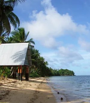
Koror isn’t just a dot on the map. It’s the old heartbeat of Palau. Rising 2,061 feet above the Pacific, just south of the massive island of Babelthuap, it holds Koror city. That’s where the people live. Where the noise is. The former capital. But the seat of power shifted in October 2006. It moved north to Babelthuap. To Melekeok. Specifically to a site called Ngerulmud, where the capitol complex now sits.
Why the Capital Moved from Koror to Ngerulmud
You might wonder why a country swaps its political center mid-20th century. It wasn’t random. Koror was overcrowded. A tiny sliver of land for too many people. Melekeok offered space. Ngerulmud means “rain tree,” named for the massive Ficus deltoidea that still grows nearby. The new capital complex wasn’t built for grandeur initially. It was built for function. And survival.
Land and Relief: The Skeleton of Palau
Palau’s geography is dramatic. It’s not flat. It’s a jagged archipelago of limestone and volcanic origins. The relief changes everything. You don’t drive across Palau. You navigate it.
Babelthuap is the big one. Flat-topped in places, but rugged along the coast. Erosion has carved it into cliffs and hidden coves. The interior is thick jungle. Dense. Green. Unforgiving if you try to hike without a guide.
Koror Island is different. Steeper. Sharper. The city clings to the slopes and the coastline. Traffic is gridlock during rush hour because the roads hug the hills. There’s no space to expand out. So they build up. Or down.
Drainage and the Limestone Puzzle
Drainage here is unique. The islands are karst landscapes. Limestone dissolves in rainwater. Creating sinkholes. Underground rivers. Caves.
When it rains—and it rains hard—the water doesn’t just run off. It disappears. Into fissures. Into the aquifers below. This affects where you can build. Where you can farm. The drainage patterns dictate the layout of villages. Not the other way around.
If you’re planning a trip, understand this: water is both a resource and a hazard. Floods can happen fast in low-lying areas, even without a storm surge. The drainage systems are natural, not engineered like in Singapore or Tokyo. They’re fragile.
What to See When You’re There
Forget the capitol complex. It’s impressive, sure. The concrete curves against the jungle backdrop. But it’s not why you’re here.
Head to Ulong Island. Off Koror. Accessible by a short boat ride. The lagoon is turquoise. The sand is white. It’s the postcard shot. But go early. By noon, the day-trippers from Palau International Cruise Center have taken over.
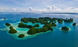
Coron Island is nearby. More rugged. Less developed. The cliffs drop straight into deep blue water. Kayaking here feels prehistoric. The limestone karsts rise like dragon teeth from the sea.
Airai State on Babelthu
Beyond the Barrier Reef
Most of Palau’s 300-plus islands are tucked inside a massive lagoon. It stretches 70 miles northeast to southwest, sealed off by a protective barrier reef. Only six islands sit outside this system. The largest, Babelthuap, covers 153 square miles. It is volcanic rock, mostly andesite. Mangrove forests line the coast, broken only by occasional sandy beaches on the east.
The highest point, Ngerchelchuus, rises 794 feet in the northwest. The island is a rolling upland. Grass meets jungle. Streams have carved a deep drainage system of three rivers. Rainfall hits hard here. About 150 inches fall annually. Erosion is significant despite stable laterite soils and heavy vegetation. Local burning of grassy areas during the dry season accelerates the process.
Connectivity and the Rock Islands
A steel bridge links Babelthuap to Koror. From there, causeways connect to Malakal Island, home to the deepwater port, and Arakabesan Island. These three small islands cover just 7 square miles. They share Babelthuap’s volcanic origin.
South of them, the landscape changes. For 28 miles down to Peleliu, you encounter over 300 “rock islands.” These are uplifted coral limestone structures. They tower up to 600 feet. Some hold interior brackish lakes. Subterranean channels connect these lakes to the lagoon. Unique organisms thrive there.
Plant growth thick on these islands. Combined with heavy rains, it sculpts the rock. The result is razor-sharp edges and broken rubble. Phosphate deposits are rich in the limestone. Accessible ones have been mined.
The Outer Islands
Living on coral islands outside the main lagoon requires adaptation. The Kayangel Islands sit 25 miles north of Babelthuap. Angaur lies 6 miles south of Peleliu. Both rest on volcanic substructures. Angaur’s phosphate was heavily mined by Germans and later Japanese.
Further southwest, 180 miles away, sit Sonsorol, Pulo Anna, and Tobi. Each is less than a square mile. They are flat platform structures with fringing reefs. You won’t find them on a casual itinerary. They are remote outliers.
Climate and Geological Stability
Palau’s climate is strictly tropical. Don’t expect seasonal shifts. Humidity stays between 77 and 84 percent. Temperatures hover in the low 80s Fahrenheit. The daily fluctuation rarely exceeds 10 degrees. It is consistent. Predictable.
Rainfall ranges from 120 to 160 inches yearly. Trade winds blow from the northeast between December and March. The southwest monsoon takes over from June to October. Ocean currents offshore include the North Equatorial Current and the Pacific Equatorial Countercurrent.
Geologically, Palau sits on the Philippine Sea Plate. It is only 30 miles west of the Palau Trench. That trench plunges nearly 26,200 feet deep. It marks the boundary of the upthrusting Pacific Plate. Despite being so close to this subduction zone, earthquakes are rare. The ground holds steady.
Diverse Marine and Terrestrial Life
The marine environment here is unmatched in density for its size. Proximity to Indonesia, New Guinea, and the Philippines brings diversity. Corals, fish, snails, clams, sea cucumbers, starfish, and sea urchins abound. You will also find sea anemones, jellyfish, squid, and feather-duster worms. This abundance makes Palau a top-tier scuba diving destination.
On land, flora is equally abundant. Beach morning glory, Polynesian ironwood trees, pandanus, palms, and ferns dominate. Birds are colorful and plentiful. Many migrate through twice a year. Reptiles and amphibians are fewer. One frog species gives birth to live young. Insects are everywhere. The coconut rhinoceros beetle, an accidental introduction, damages palms. Biological controls are used to manage it.
Ethnic Origins and Languages
Settlement began 2,000 to 3,000 years ago. Successive waves arrived. Malays from Indonesia came first. Then Melanesians from New Guinea. Philippine natives followed. Some Polynesians drifted in from outer islands. This mix created a diverse population.
Since the late 18th century, Europeans, Japanese, and Americans have added to the mix. The southwest islanders are culturally and linguistically distinct. They descend from survivors of canoes that drifted from Ulithi Atoll to Sonsorol.
Palauan is the primary language. It is Western Austronesian. Grammatically, it is complex. Irregularities make strict rules difficult. Sonsorolese-Tobian is spoken on the southwest islands. English is also official. All three hold status.
Religious Landscape
Indigenous Palauan religion focused on powerful ancestral and nature spirits. Christianity supplanted it. Missionaries arrived and converted the majority.
Slightly more than half the population is Roman Catholic. Just over a quarter is Protestant. Smaller groups include Seventh-day Adventists, Jehovah’s Witnesses, and Mormons. The spiritual landscape reflects this history.
Who lives in Palau and why it matters for your trip
If you are planning a visit to Palau, you are walking into a demographic mosaic that is distinct across Micronesia. Historically, Palauans have been more likely to migrate abroad than their neighbors. This isn’t just a statistic; it’s a visible reality. You will find substantial Palauan communities in Hawaii, on Guam, and along the U.S. West Coast.
But the island itself is also a destination for outsiders. Since the late 20th century, immigration has surged, driven largely by foreigners seeking work, particularly from the Philippines. By the early 2000s, foreigners made up more than a quarter of the population. Today, that number is even higher. Foreigners account for over two-fifths of the paid workforce, with significant communities from the Philippines and Taiwan.
This mix shapes the culture you encounter. It means your dining options, service industry interactions, and even the local slang might reflect a blend of Pacific Islander roots and Asian influences. It’s not a monolith. It’s a working society.
The economy: What powers Palau
The economy of Palau is a study in contrasts. On paper, it’s one of the wealthiest places in the region. Per capita income is high. But dig deeper, and you’ll see the scaffolding.
Since World War II, the government has been the biggest employer. First the U.S. Navy, then the Trust Territory of the Pacific Islands, and now the Palauan government. If you are looking for private sector jobs outside of tourism, you might find the landscape thin.
In rural areas away from Koror, the subsistence economy is alive and well. Women cultivate taro, sweet potatoes, and cassava. Men fish and tend pigs. These pigs aren’t just livestock; they are central to customary feasts. This isn’t a museum piece. It’s daily life. Nearshore reef fishing supports this, but it doesn’t generate much government revenue.
Where does the money come from?
– Foreign tuna fishing licenses: Offshore tuna fishing by foreign vessels provides a small but steady stream of government income.
– Exports: Tuna and clothing are the main exports. There are no major cash crops for export.
– Tourism: This sector has grown considerably since the late 20th century and continues to drive economic growth.
The currency is the U.S. dollar. There is no central bank. Palau joined the International Monetary Fund in 1997. Financial regulations tightened in the early 2000s following allegations of money laundering in 1999. If you are a traveler, this stability means your dollars go further, and ATMs work. Be aware, however, that the minimum wage law adopted in 1998 does not apply to foreign workers.
Getting around: Roads and routes
Infrastructure in Palau is functional but not sprawling. Koror, the commercial hub, has a system of paved roads. Babelthuap, the main island, also has stretches of paved road.
The standout project is the Compact Road. Construction began in the mid-1990s and finished in 2007. It is a 53-mile (85-km), two-lane highway. The name comes from the Compact of Free Association, which required its construction. It connects key parts of Babelthuap and is the best paved route for exploring the island’s interior.
On Peleliu and Angaur, you will still see roads built by U.S. military forces between 1944 and 1946. They are still usable, offering a historical perspective on the terrain.
Transportation between islands is primarily by boat or airplane.
– Regular commuter service runs from Koror to Peleliu and Angaur.
– Speedboats connect Koror to coastal villages on Babelthuap. These trips usually take just a few hours.
– International airport is located on Babelthuap, not Koror. This is a crucial logistical detail for your flight planning.
If you are renting a car, the Compact Road is your best bet. If you are sticking to Koror, paved roads are sufficient. For the islands, you need patience. Boats are subject to weather and schedule. Plan around them, not the other way around.
Government and society
Palau operates under a presidential republic system. The government structure is modern, but social traditions remain deep-rooted. The constitution allows for unions, but at the start of the 21st century, no such organizations existed. Labor dynamics are shaped by the high percentage of foreign workers and the government’s role as the primary employer.
For a traveler, this means respecting local customs is paramount. The blend of subsistence living and modern governance creates a society that is both open to visitors and protective of its traditional ways. When you see a pig being prepared for a feast, or taro being
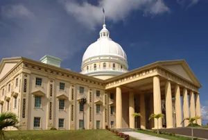
The Political Architecture of an Island Nation
Palau runs on a specific set of rules. The constitution, adopted in 1981, locked in a presidential system that still holds today. You have a separately elected president and vice president. They don’t work alone. The Council of Chiefs sits alongside them, advising on traditional laws and customs. A cabinet handles the day-to-day executive burden.
Then there is the Olbiil Era Kelulau, or National Congress. It’s split into two chambers: the Senate and the House of Delegates. Everyone in both the executive and legislative branches serves four-year terms. If you are 18 or older, you get to vote. The judiciary stands apart. It’s built on a Supreme Court with trial and appellate divisions, a Court of Common Pleas, and a Land Court that likely handles the complex property disputes common in island cultures.
At the local level, power is fragmented. There are 16 traditional settlement areas. Each one is a state. Each has its own elected governor and legislature. There is no army. The United States handles defense. Some Palauans do volunteer for the U.S. armed forces, but the island itself has no standing military.
Schools and Literacy Rates
Compulsory education kicks in at age six and lasts until 14. Or until the student finishes eighth grade. Whichever comes later. The system mixes public and private elementary and secondary schools. Instruction happens in both English and Palauan.
Higher education is tricky. There is no university on the islands. But the Palau Community College (founded in 1993) steps in. It offers vocational and academic courses. It’s open to students from all over Micronesia. Its roots go back to a vocational school from the 1920s, during the Japanese administration. For those who want to go further, government scholarships send young Palauans to universities abroad. The result? Near-total adult literacy. The system works, even if it relies on external partnerships.
Health Challenges and Care
Healthcare is centralized on Koror. The main hospital handles the heavy lifting. Field dispensaries and a handful of private clinics stretch services into remote areas. It’s not a perfect network. Gaps exist.
The real issue isn’t infrastructure. It’s human. The incidence of mental illness, suicide, and alcoholism in Palau is significantly higher than in most other countries. You can’t fix that with better clinics alone.
Cultural life
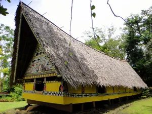
The Palauan Survival Strategy
It isn’t just about surviving. It’s about adapting.
Palauan society has a reputation for being pragmatic. Then there is persistence. And competition. Take your pick. These three things define the rhythm of daily life on the islands.
Think about the history. A century of colonial intrusion doesn’t just pass you by. You have to deal with it. Spanish. German. Japanese. American. Each wave brought its own set of rules. The Palauan response wasn’t to resist everything. It was to view reality as something imposed from the outside. Quick adjustment is necessary. If you want to manipulate that reality, you have to be fast.
This mindset shapes how wealth moves through the community.
Reciprocity and Redistribution
Wealth exchange isn’t a transaction. It’s a custom.
Reciprocity and redistribution still rule. These practices happen between clans. Food and services are exchanged for money and gifts. The occasions are specific. Births. House completions. Funerals.
Money changes hands. Gifts are given. The flow is constant.
Women hold the real power here. They are the strength of society. They control land. They manage money. They hold titles.
Men used to be fishermen. Warriors. That’s the traditional role. In rural areas, they still do those tasks. But there’s a twist for modern society. Men now compete for elected office. They compete in business. The old roles remain. The new ones have been added.
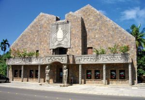
Cultural Preservation and Modern Entertainment
You won’t find the old men’s clubs bustling with their original chants anymore. Those traditions haven’t vanished, but they’ve shifted. Storyboards and chants are now crafted for tourist consumption rather than communal decoration. If you want to see where this history lives physically, head to Koror. The Belau National Museum, established in 1955, holds a small but sharp collection of artifacts. It’s worth the hour. Then there’s the Etpison Museum, opened in 1999. It’s less about heavy artifacts and more about context—photographs, maps, and cultural items that tie the dots together.
Out on the water, the vibe changes. Palau is a maritime nation, and the sports reflect that. But there’s a twist. Baseball is gaining serious traction here. It’s not just a pastime; it’s becoming a cultural fixture. For a deeper dive into the broader Micronesian context, you’ll need to look beyond the islands themselves, but for Palau-specific grit, the museums and the water are your starting points.
Pre-Colonial Foundations and First Contact
Before the Europeans showed up, Palau was already structured. Look at Babelthuap. The hillside terraces, the stone ruins, the megaliths—they’re not just ruins. They are evidence of a complex, vital culture that existed long before Western maps claimed the territory. The first major Western contact happened in 1783 when the East India Company’s packet ship Antelope wrecked. It wasn’t a smooth arrival. It was chaos.
George Keate wrote An Account of the Pelew Islands in 1788. His book didn’t just report news; it fueled a myth. It painted Palau as a paradise inhabited by “noble savages.” That narrative stuck, shaping how Europe viewed the region for decades. Throughout the early 1800s, whalers and traders drifted in and out. They left behind beachcombers and firearms. The firearms changed everything. They weren’t just tools; they were weapons for intervillage warfare, sparking conflicts that had existed for generations but were now amplified.
Disease also ravaged the population. Europeans brought sickness that islanders had no immunity against. Deaths mounted. It wasn’t until 1883 that Captain Cyprian Bridge of HMS Espiegle stepped in. His intervention ended the warfare peacefully. It was a temporary reprieve, but it set the stage for the next wave of colonization.
Colonial Handoffs and World War II
The colonial baton was passed around like a hot potato. First came the Spanish and Germans, bringing Roman Catholic missionaries with them. Then came the Japanese. At the start of World War I, the Japanese navy expelled the Germans. Locally, the Japanese period is often remembered for economic development and order. There was stability. But look closer at 1936. By then, Palauans were a marginal minority in their own land. The demographic shift was stark.
World War II shattered that order. The struggle for control of the islands was socially destabilizing. It left the Palauans confused and caught in the crossfire. The Japanese loss wasn’t just a military defeat for Tokyo; it was a traumatic rupture for the local population.
After the war, the U.S. Navy took a short administrative turn. Then, in 1947, the United Nations placed Palau under a Trust Territory, administered by the United States. This period laid the groundwork for the political structures we see today.
The Road to Independence and the Nuclear Clause
Independence wasn’t a straight line. It was a series of referendums, constitutional debates, and political assassinations. A constitution was adopted in 1981. Elections happened the same year. Palau became internally self-governing. But the big hurdle was the Compact of Free Association with the United States, signed in 1982.
Here is where it gets complicated. Palau’s constitution explicitly prohibited the operation of U.S. nuclear-powered or nuclear-armed vessels and aircraft within its jurisdiction. The United States refused to accept that restriction. They reserved the right to neither confirm nor deny the presence of such weapons. This deadlock stalled the compact’s ratification.
The political violence was real. In 1985, the first president, Haruo I. Remeliik, was assassinated. Lazarus E. Salii was elected to finish the term but committed suicide in 1988. It was a dark period. But by the early 1990s, politics stabilized.
The breakthrough came in 1992. Voters approved an amendment that lowered the threshold to override the antinuclear provision from three-fourths to a simple majority. This cleared the path. In 1993, the compact was approved. Palau officially became independent in October 1994. It joined the United Nations in December of the following year. The U.S. remained responsible for defense and provided financial assistance. The nuclear clause was effectively neutralized by the constitutional amendment.
Infrastructure Collapse and Recovery
In September 1996, the infrastructure holding the nation together failed. The bridge connecting Koror with Babelthuap collapsed. Two people died. The economic havoc was immediate. Koror, the capital, was cut off from the international airport on Babelthuap. It was isolated. Telecommunications, water, and power were disrupted for most of the population. The country was paralyzed.
The response came from Japan. The Japanese government contributed $25 million for a replacement bridge. They didn’t just rebuild what was there. They changed the design. The new bridge is a suspension design, not the concrete cantilever of the original. It opened in 2002. It’s a symbol of both disaster and resilience.
Modern Alliances
Palau’s modern foreign policy is defined by its relationship with the United States. During the Iraq War, Palau lent its support to the U.S.-led coalition. Palauan troops served as part of the U.S. military. It’s a testament to the Compact of Free Association. The alliance is deep. It’s practical. And it’s ongoing.
Travelers today walk on soil shaped by these collisions. The museums in Koror are quiet. The water is loud with activity. The baseball fields are filling up. The bridge stands firm. The past is visible in the stone terraces. The future is negotiated in Washington and Koror alike. You can see the layers. You can touch them. The question is how much of the myth you want to engage with, and how much of the reality you’re willing to accept.