


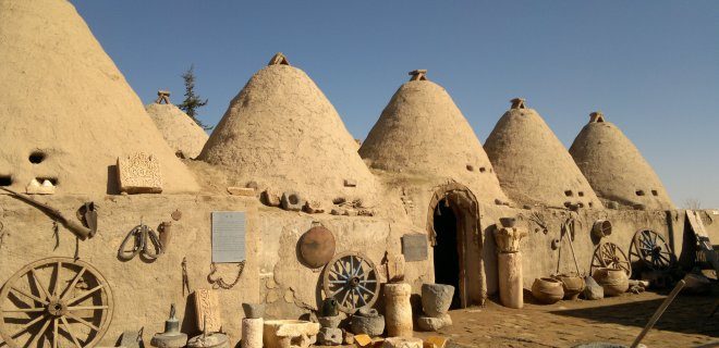
The soil of Southeastern Anatolia is not just dirt. It is the cradle. This is Mesopotamia, where human history began to take shape. Here, standing tall against the erosion of time, are architectural ruins that have witnessed millennia of rise and fall. These structures are not museum pieces behind glass. They are woven into the fabric of the people who still live here.
But the future looks bleak for many of them.
The construction of the Atatürk, Birecik, and Ilısu dams has sealed the fate of ancient sites. Hasankeyf, a city that once breathed life into the region with its river and rugged landscape, is slated to be submerged. The water is coming. If you are planning a trip to Turkey, do not wait. Visit this magnificent ancient city while it still exists above ground.
“Don’t just look and move on. Touch them slowly. Try to understand what they are trying to tell you.”
Beyond the doomed monuments, other historical sites in the region are ignored. They lack the “wow” factor for quick tourists. But if you slow down, they speak. Each stone has a narrative. It is a shame to rush through them.
Let us start the exploration not with a flood victim, but with a survivor that still stands.
Discovering the Unique Architecture of Harran Houses
The Harran Oval is vast. It is flat. It feels endless. But the real draw here is not the landscape. It is the housing.
The Harran Evleri are distinct. You will recognize them from a mile away. They look like giant beehives scattered across the desert plain. These are not your average Ottoman stone houses. They are a vernacular architecture born from necessity and climate.
Why the Beehive Shape?
You might wonder why they look like that. The shape is not aesthetic preference. It is engineering. The thick, rounded walls provide thermal mass. They keep the interior cool during the scorching summer days and retain heat during the freezing winters. This is passive air conditioning designed by ancestors who had no electricity.
The roofs are domed. Often covered with vegetation or simple materials. They channel rainwater into cisterns. Every inch of these homes is designed for survival in an arid environment.
What Makes Harran Worth Visiting?
- Direct Experience: You can still find people living in these homes. Some are renovated for tourism. Others are crumbling ruins. Walking through the narrow streets feels like stepping into a living museum.
- Historical Layers: The town sits on a tell (mound) that has been inhabited for over 7,000 years. The current structures are from the Islamic period, but the ground beneath is ancient.
- Photography Opportunity: The contrast of the white, dome-shaped houses against the brown, dusty plains is striking. It is a photographer’s dream.
Practical Logistics for Harran
- Location: Harran is about 50 kilometers southwest of Şanlıurfa.
- Transport: You need a car or a local taxi. Buses run frequently from Şanlıurfa, but they will drop you off. You will need to walk or take a short taxi ride to the

Why Harran Feels Like a Time Capsule in the Middle of a Desert
You step out of the car and the heat hits you first. It’s not just warm; it’s heavy. This is the Harran Plain, and if you’re expecting lush greenery, you’re in for a shock. Locals call it an ova, a plain, but it’s barren. No grass. No trees. Just endless, flat earth baking under the sun.
It feels wrong, doesn’t it? A plain should be green. But science says it wasn’t always this way. Millennia ago, this was a fertile district. Over time, human exploitation and shifting climates drained the land dry. Think of it like an old cow that’s been milked too long without rest—the soil simply gave up. It’s exhausted from supporting civilization for thousands of years.
But don’t let the aridity fool you. You are standing on ground that has seen everything. When you walk here, you aren’t just looking at dirt. You’re hearing echoes. You need to see the beehive houses. You need to see the museums. They anchor the experience.
As you travel toward Şanlıurfa, you’ll notice something strange on the walls. Murals. Paintings. And one quote appears everywhere.
“Edeple Gelen Lütufla Gider”
What comes with humility leaves with grace.
It’s attributed to Mevlana, and it’s plastered across the city. It’s not just decoration. It’s a warning. And a promise.
The Ghost City of Şuayip
Just past the main draw of Harran lies something darker. The City of Şuayip.
It’s not on every tourist checklist. That’s good. It keeps the air quiet. This is a ruin, but not in the way you picture Greek ruins. It’s buried. It’s hidden. You have to look for it.
The name Şuayip sounds ancient. It sticks to the tongue. The site itself is fragmented. You’ll see foundations. Low walls. The skeleton of a civilization that decided to pack up and leave. Or maybe they were forced out. The stones don’t tell you why. They just tell you that people were here.
Visiting Şuayip requires effort. You won’t find a grand entrance with ticket booths. It’s rougher. Dustier. You have to wander into the outskirts and pick through the debris. But that’s the point. It’s not a show. It’s a discovery.
Logistics for the Journey
You can’t do this trip on a whim. The heat in Şanlıurfa is no joke. If you go in July, you’ll regret it. Stick to spring or autumn. The light is better too. Harsh midday sun washes out the details of the beehive houses. Morning or late afternoon light cuts through the shadows, showing you the texture of the mud-brick.
Costs are manageable here compared to Istanbul or Antalya. Entry fees for the Harran mounds are low. The beehive houses you can often just look at from the outside or pay a nominal fee to step inside one. It’s cheap. It’s authentic.
Transport is your main variable. You need a car or a very determined driver. Public transit gets you to Şanlıur
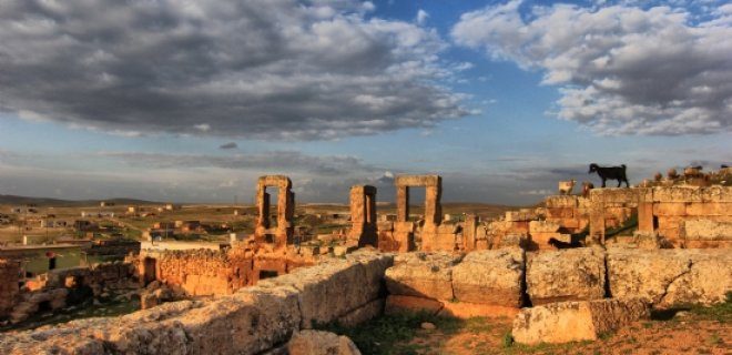
The Ancient Ruins of Şuayip City and the Legend of Balıklı Göl
Forty-five kilometers west of Harran, the road to Şuayip City winds through flat, sun-bleached terrain. It is a drive that feels like stepping backward in time. The ruins here are not grand like the marble columns of Ephesus. They are quiet. They are broken. And they are deeply significant for anyone tracing the layers of Roman history in Southeastern Turkey.
You will find hundreds of rock-cut tombs carved directly into the limestone cliffs. These are not just burial sites; they are windows into a society that valued permanence even in stone. The structures speak of a Roman-era presence that often gets overshadowed by the more famous sites in Cappadocia or Ephesus. But here, the history is raw. You can walk among the columns that once held up temples. You can see the weathered faces of statues that have stared at the desert wind for two millennia.
The true pull of Şuayip, however, is spiritual. Deep within the site lies a cave known as the tomb of Prophet Shuaib. For believers, this is a destination of pilgrimage. For travelers, it is a moment of stillness. The air inside is cool. The light is dim. It is easy to understand why this place has held reverence for centuries.
Just a short drive away lies the heart of Urfa’s spiritual identity: Balıklı Göl, or the Pool of the Holy Fish.
This is not just a park. It is a lake steeped in myth. The water is black, still, and unnervingly clear. Legend says this is where Prophet Abraham was thrown into a fire by King Nimrod, but the flames turned into water and the wood into fish. The fish that inhabit this pool are considered sacred. They are the descendants of those legendary survivors.
Visiting Balıklı Göl requires a shift in mindset. You are not just sightseeing. You are entering a space of profound religious importance for Jews, Christians, and Muslims alike. The fish do not flee from your hand. They are fed daily by devotees who toss in bread. They swarm around you with a calm, almost expectant curiosity. It is a surreal experience to stand knee-deep in holy water while thousands of fish circle your legs.
The surrounding area is lined with small shops selling dried fruits, spices, and souvenirs. But the real attraction is the atmosphere. In the evening, the mosque lights up. The call to prayer echoes off the water. The fish continue their slow dance.
Why do people come here? Is it the history of the Roman tombs in Şuayip? Or is it the living legend of the fish in Urfa? Perhaps it is both. It is the sense that in this part of Turkey, the past is not dead. It is swimming beneath your feet. It is carved into the cliffs. It is waiting for you to listen.
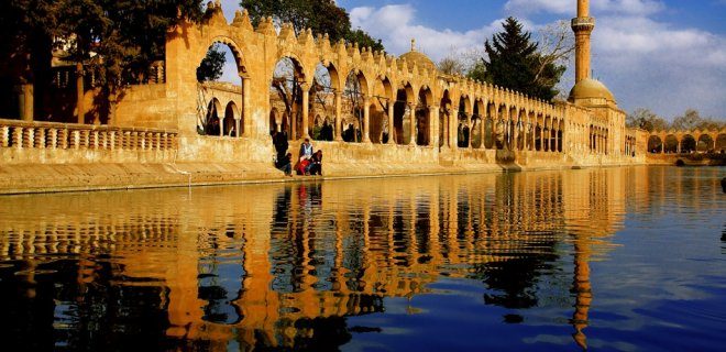
The Legend Behind Urfa’s Sacred Waters
The story of Prophet Ibrahim is woven into the very soil and water of Şanlıurfa. At the center of this local mythology stands Balıklı Göl, a lake that draws more visitors than perhaps any other site in the city. The tale is ancient and dramatic. It begins with a clash of ideologies. Prophet Ibrahim fought against the idolatry promoted by King Nemrut. But the conflict was also deeply personal. Ibrahim fell in love with Nemrut’s daughter. This forbidden romance gave the king a motive for revenge.
Nemrut ordered a massive fire to be built at the site of the current lake. He threw Ibrahim into the flames. According to tradition, the fire instantly turned into cool water. The logs in the fire transformed into fish. This divine intervention saved Ibrahim and created a sacred site.
Why Balıklı Göl Is a Pilgrimage Destination
Today, the lake hosts a steady stream of tourists and pilgrims. It is not just a scenic spot. It is a place of active belief. The history here is palpable. You are standing where legend says divine power altered reality. The lake itself is framed by historical structures that have withstood centuries.
Behind the main lake lies a smaller, quieter body of water. This is Ayn-ı Zeliha Gölü. It is named after Zeliha, Nemrut’s daughter. The legend says she threw herself into these waters after the incident with Ibrahim. The connection between the two lakes is both geographical and narrative. They sit together as monuments to the same story.
How to Experience the Belief Around the White Fish
Travelers come for the history. Many stay for the ritual. The belief surrounding the white fish in Balıklı Göl is specific. It requires precise timing. You must visit on a Friday morning. You must arrive after the morning prayer. Then you look into the water.
If you see a white fish swimming in Ayn-ı Zeliha, your wishes are said to come true. This is not a vague suggestion. It is a specific condition tied to the day and the location. The white fish are a unique feature of this ecosystem. They are protected. Feeding them is generally discouraged to preserve their health and the sanctity of the site.
Halfeti: The Dark Rose of Şanlıurfa
Just north of Urfa lies Halfeti. Often called the “Dark Rose” of the region. This village sits on the banks of the Euphrates. It is a stark contrast to the arid plains of the city. The landscape here is lush. The architecture is distinct. Stone houses cling to the cliffs.
The area was partially submerged when a dam was built nearby. Some of the old buildings still rise from the water. This creates a haunting beauty. Visitors often take boat tours to see the submerged minarets. The journey takes you away from the crowded tourist traps. It offers a quieter reflection on how nature and human engineering intersect.
Practical Tips for the Traveler
- Best Time to Visit: Early morning on Fridays is key for the ritual. However, the weather is most pleasant in spring or autumn. Summers in Şanlıurfa are extreme.
- Getting There: Balıklı Göl is within walking distance of the city center. Halfeti requires a short drive or tour.
- **
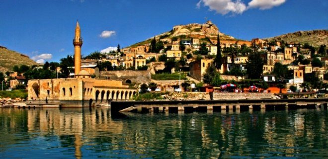
Halfeti’ye gelin diyenler, Fırat’ın sularına hüzünle bakmayı da göze almalı. Şanlıurfa’nın en eski yerleşim yerlerinden biri olan bu kasaba, son yıllarda Karagül dizisiyle birlikte milyonların gözdesi haline geldi. Güzelliği o kadar etkileyici ki, Güneydoğu’nun en önemli duraklarından biri oldu. Her yıl daha fazla insan sıradan tatil beldelerinden vazgeçip Halfeti’ye akıyor. Burada sizi masmavi gökyüzü, tarihi yapılar ve muhteşem bir manzara karşılıyor. Ülkede siyah gülün yetiştiği tek yer olarak bilinen Halfeti, Şanlıurfa’nın en yeşil bölgesi konumunda. Ancak ne yazık ki Fırat Nehri üzerinde inşa edilen Birecik Barajı nedeniyle, kasabanın en tarihi noktaları şu an sular altında kalıyor. Bu durum, yerin ruhunu korumak adına ciddi bir tehdit oluşturuyor.
Nemrut Dağı / Adıyaman
Dünya mirası statüsüne sahip Nemrut Dağı, Adıyaman’ın en ikonik ve etkileyici doğa harikalarından biri. Burası, antik Kommagene Krallığı’nın son kralı I. Antiochos’un mezarı üzerine inşa edilen devasa bir anıt complexi. Dağın zirvesinde bulunan bu tarihi kalıntıları görmek, Türkiye’deki en unutulmaz deneyimlerden biri.
Nemrut Dağı’na tırmanmak zorlu ama ödüllü bir yolculuk. Dağın eteklerinden başlayarak yaklaşık 2.143 metrelik zirveye doğru yürüyüş yapmak gerekiyor. Bu yolda sizi büyük taş başlar, aslanlar, kartallar ve dev heykeller karşılayacak. Heykellerin çoğu başsız olsa da, devasa boyutları ve tarihi önemi sizi büyülemeye yetiyor.
En iyi ziyaret zamanı, ilkbahar veya sonbahar ayları. Yazın zirve çok sıcak ve rüzgarlı olabilir. Kışın ise yollar kapalı veya kaygan olabilir. Erken saatlerde veya güneş batımında gitmek, manzaranın en iyi haliyle tanıklık etmek için idealdir. Güneşin dağın arkasına batarken, heykellerin gölgeleri uzayıp kısalıyor. Bu anı kaçırmayın.
Nemrut Dağı’na ulaşım için Adıyaman merkezinden kalkan minibüsleri veya özel araçlarla gitmek mümkün. Yol, dağın eteklerinden başlayarak virajlı ve dar bir yokuş çıkışı içeriyor. Dikkatli sürüş gerekiyor. Yerli ve yabancı turistler için popüler bir destinasyon olan Nemrut Dağı, UNESCO Dünya Mirası Listesi’nde yer alıyor. Bu statü, bölgenin korunması ve restore edilmesi için önemli bir güvence sağlıyor.
Heykellerin detaylarına bakarken, antik Yunan ve Pers kültürlerinin birleşimini görebilirsiniz. I. Antiochos, tanrılarla kendi arasında
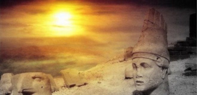
Nemrut Dağı’nda Gün Doğumu ve Gün Batımı: Efsanevi Anlar
Adıyaman’a geldiyseniz, Nemrut Dağı’nın sadece bir UNESCO Dünya Mirası olarak listelenmesi yeterli değil. Tepedeki dev heykeller, yüzlerce yıl öncesine ait anıt mezarlar ve o muazzam manzara… Bunlar, görmek için değil, hissetmek için var. Özellikle gündoğumu ve günbatımı saatlerinde tepeye çıktığınızda, tarihin en büyük sahnesinin içinde olduğunuzu hissedersiniz. Dünyanın en güzel yapılarından biri olması tesadüf değil.
Yeni Kale / Kahta’da Konaklama ve Ulaşım Detayları
Nemrut Dağı’na tırmanmak zorlu bir iş. Soğuk, rüzgarlı ve yokuşlu. Bu yüzden Yeni Kale olarak da bilinen Kahta ilçesinde kalmanız şart.
- Nerede Kalınmalı? Nemrut Dağı Milli Parkı’na 20-30 dakika uzaklıktaki Kahta merkezinde otel veya pansiyon bulun.
- Ulaşım: Kahta’dan özel araç veya tur ile Nemrut Dağı’na çıkılır. Yol asfalt olup son birkaç kilometre kırık dökük olabilir.
- Zamanlama: Gün doğumu için gece 03:30’da çıkış yapılır. Gün batımı için ise akşamüstü 4-5 arası tepeye çıkılır.
“Nemrut Dağı’nı sadece bir fotoğraf noktası olarak değil, bir deneyim olarak görün.”
Heykeller ve Anıt Mezar: Neden Görülmesi Gerekiyor?
Tepeye çıktığınızda ilk gördüğünüz şey, taşın içindeki devasa başlar. Antiochos I’in babası Komagene Krallığı’nın tanrıları ve kralları…
- Zeus-Oromasdes: En büyük heykel. 10 metre yüksekliğinde.
- Apollo-Mihrd-Artagnes: Güneş tanrısının temsilcisi.
- Herakles-Antiochos I: Krallığın kurucusu.
Bu heykellerin ayakları yok. Neden? Zamanın ve doğanın işi. Ama başları hala ayakta. Gözleri size bakar. Hissetmeniz gereken şey, bu taşların sadece taş değil, inanç ve güç sembolü olduğu.
UNESCO Dünya Mirası statüsü, bu yeri korumak için verilmiş. Ama siz orada olduğunuzda, onun ne kadar özel olduğunu zaten anlayacaksınız.
Pratik İpuçları: Ne Giymeli? Ne Getirmeli?
- Sıcaklık: Dağın tepesinde hava her zaman soğuk. Yazın bile rüzgar keskin. Kalın mont, bere, eldiven şart.
- Ayakkabı: Toprak yolu ve kayalık alanlar. Krampon veya sağlam spor ayakkabı giyin.
- Su ve Yiyecek:
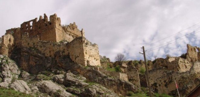
New Castle: A Hidden Gem Near Adiyaman
Just 60 kilometers from Adiyaman, in the vicinity of Kocahisar village, stands Yeni Kale (New Castle). This isn’t just a random ruin; it was built by the Commagenians, a kingdom known for blending Greek and Persian cultures. The structure still breathes history through its remaining caravanserai, mosque, dovecote ruins, water channels, and inscriptions.
Most of what you see today dates back to a partial restoration done in 1970. But the real draw? The underground tunnel system. Yes, you can actually walk through tunnels inside the castle to reach fresh water. It’s a rare feature that speaks to how self-sufficient this fortress needed to be.
If you’re planning a visit:
– Timing: Go early in the day. The stone gets hot, and shade is limited.
– Access: The site is accessible by car, but the last stretch might be rough.
– What to see: Focus on the water channels and the tunnel entrance. They’re the most intact and interesting parts.
– Nearby: Combine your trip with a stop in Adiyaman city for authentic local cuisine.
It’s not as crowded as some of Turkey’s major sites, which means you can actually hear yourself think. And maybe even imagine the Commagenian kings walking these same paths.
Diyarbakır Surları
Then there’s Diyarbakır. Specifically, the Sur Walls. These aren’t just walls; they’re a statement. Made of black basalt, they’re among the oldest and best-preserved in the world. You’ll walk along the ramparts and look down at the city below, feeling the weight of centuries.
It’s a stark contrast to Yeni Kale. Where Yeni Kale is quiet and tucked away, Diyarbakır’s walls are loud, alive, and central to the city’s identity.
How to experience it:
– Walk the full circuit: It takes about 2-3 hours. Don’t rush.
– Visit the gates: The Midyat Gate and Civankapı are particularly striking.
– Best time: Late afternoon when the light hits the black stone just right.
The walls have seen empires rise and fall. They’ve been repaired, rebuilt, and sometimes damaged. Yet they stand. And when you touch them, you’re touching something that’s outlasted almost everything else.
Why do we travel? Sometimes it’s for the view. Sometimes it’s for the silence. And sometimes, it’s just to stand in front of something so old it feels alive.
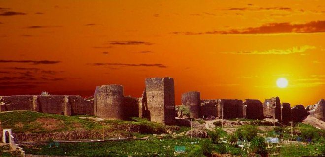
Why the Diyarbakır Walls Are Your Best Photo Op
Let’s be real: if you’re standing in Diyarbakır, you’re standing in the shadow of something massive. The Diyarbakır Sur (Walls) aren’t just a historical footnote; they are a physical weight. Stretching 5.5 kilometers long and rising 7 to 8 meters high, these fortifications are so vast that they often get ranked as the second-longest city walls in the world, right after the Great Wall of China. It’s a heavy title for a place that feels so grounded in the earth.
The exact date of their construction is lost to time. No one knows who laid the first stone or when the last one was set. What we do know is that this structure is anchored near the city center, acting as a boundary between the old quarter and the bustling modern streets.
How to Navigate the 16 Towers
Walking these walls is an exercise in scale. There are 16 watchtowers scattered along the perimeter, each one a stone giant watching over the Tigris River. But here’s the thing: don’t just walk the top. The real energy is inside.
Between the towers, you’ll find entrances to the inner structures. These aren’t empty shells. They are alive with commerce and culture.
- Traditional Textiles: Look for vendors selling şal (shawls) and traditional Kurdish clothing. The wool is thick, the patterns intricate, and the bargaining is part of the experience.
- Street Food: You can eat inside the walls. It’s not just tourist traps; you’ll find places serving hot, fresh pide or kebabs right under the arches.
It’s a unique blend of history and daily life. You’re walking where armies marched, but you’re buying a scarf and grabbing a bite to eat.
The Logistics of Seeing It
Getting there is easy. The walls surround the historic center (Sur district), so once you’re in, you’re in. There isn’t a single “main” gate that everyone uses; there are five exit points (kapı).
Which gate is best for you?
– If you want the classic postcard view, head toward the Zeydanlı Kapı or Maraş Kapısı.
– For a quieter walk with better sunset views over the river, aim for the western sections.
– Timing: Go late afternoon. The limestone turns golden, then pink. The shadows in the towers stretch out. It’s the only time the stone feels warm.
Beyond the Stone: A Quick Look at Malabadi
You can’t talk about Diyarbakır’s infrastructure without mentioning its engineering siblings. Just north of the city, in the Suruç district, sits the Malabadi Bridge. It’s not a wall, but it’s part of the same ancient narrative.
While the walls defend the city, the Malabadi Bridge connects the world. Built during the Artuqid dynasty, it’s a stark, beautiful arch that spans the Dicle River. If the walls are about staying in, the bridge is about going out.
Most travelers treat them as two separate legs of the journey. Spend the morning walking the walls. Spend the afternoon driving up to the bridge. The contrast is stark: enclosed
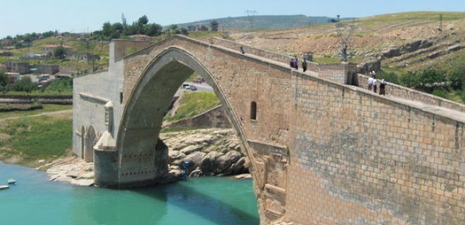
The Malabadi Bridge: A Masterpiece of Medieval Engineering
The Malabadi Bridge isn’t just a crossing. It’s a statement. Standing in Diyarbakır, this structure defies the limitations of its time. Built by the Artuklu Beylik in 1147, it holds the title for the widest stone arch span in the world.
Locals call it the bridge on the Batman-Silvan road. But the name doesn’t capture the scale. The municipality of Silvan restored it in 1989, breathing new life into weathered stone. The bridge is a mosaic of colorful rocks, pieced together over centuries. Repairs have kept it standing, but the original ambition remains.
Travelers often ask how this was possible. The answer lies in the sheer audacity of the design. Albert Gabriel, the renowned archaeologist, put it best. He noted that in an era without modern static calculations, creating a span of this magnitude was nothing short of miraculous. It demanded admiration then. It demands awe now.
Even historical travelers were blown away. Evliya Çelebi, in his famous Seyahatname, claimed the dome of the Hagia Sophia could fit underneath the Malabadi Bridge. Hyperbolic? Maybe. But it signals the sheer vertical and horizontal dominance of the work. It’s not just a bridge. It’s a monument to human ingenuity.
Dara Ruins: The Ghosts of Mardin
Just west, in Mardin, the Dara Ruins offer a different kind of silence. These aren’t just rocks. They’re the remnants of a massive Byzantine fortress-city.
Visiting Dara feels like stepping into a history book that’s been left out in the rain. The walls still stand, scarred by time and conflict. It was a strategic military site, built to guard the border. Today, it guards memories.
Unlike the living, functional Malabadi Bridge, Dara is a ghost. It’s quieter. Heavier. You walk through arches that once channeled water and troops. Now, they channel wind and birds.
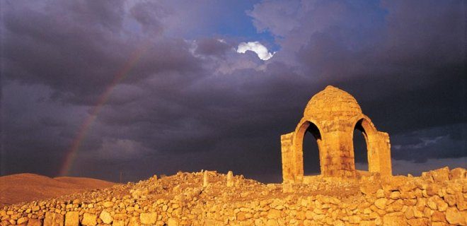
Darı Harabeleri: Mardin’in Gizli Bizans Mirası
Mardin’in güneydoğusuna, Oğuz Köyü’ne doğru 30 kilometrelik bir yolculuk yapmanız gerekiyor. Burada bekleyen şey sadece bir harabe değil, Mezopotamya’nın en büyük Bizans şehirlerinden biri olan Dara’nın devasa gölgeleri. Şehrin etrafını dolaşmak 8 ile 10 kilometreyi buluyor. Bu mesafe, tek bir günün yorucu geçmesine neden olabilir.
Tarihi dokuyu hissedeceğiniz nokta burası. Mağaralar. Yüzlerce yıllık evler. Kiliseler. Bir zamanlar sarayların olduğu yerler. Çarşılar. Ve en karanlık köşeleri, zindanlar. Her taşın altında bir hikaye var.
Neden burayı Mardin seyahatinizin bir parçası yapmalısınız? Çünkü Dara, Mardin kentinin kalabalık turistik akımından sıyrılan, sessiz bir zaman makinesi. Mardin Evleri’ni gezip tarihe doyduktan sonra, bu surların gölgesinde durmak, o devasa ölçeği zihninizde canlandırmanızı sağlar.
Gezilecek Yerler ve Logistikk
Dara’dan dönerken Mardin merkezine geçmek mantıklı. Mardin evleri, taş işçiliği ve o dar sokaklar sizi bekliyor. Ancak öncelik sırası önemli. Sabah erken saatlerde Dara’ya gidin. Sıcak hava yükselmeden, gölgelerde gezmek daha rahat. Mardin merkezine öğleden sonra geçin. Güneş batarken evlerin taşları kızarıyor. O anı kaçırmayın.
Nasıl gidilir?
Mardin şehir merkezinden otobüs veya taksiyle Oğuz Köyü’ne ulaşım sağlanıyor. Yolun bir kısmı engebeli olabilir. Araç kullanıyorsanız dikkatli olun. Toplu taşıma ile gidiyorsanız, Oğuz Köyü durağında inip harabelere yürümeniz gerekebilir. Mesafe kısa ama yokuş var.
Ne Giymeli?
Yürüyüş ayakkabısı şart. Taşlar kaygan olabilir, özellikle eski zamanlarda. Hafif, nefes alan kıyafetler tercih edin. Gölgeler az, güneşten koruyucu bir şapta veya bere unutmayın.
Neden Önemli?
Dara, sadece bir yerleşim yeri değil. Bir savunma hattı. Bir ticaret merkezi. Savaşların yaşandığı, imparatorlukların çarpıştığı bir nokta. Bugün burada ayak bastığınızda, o dönemin gürültüsünü değil, sadece rüzgarın sesini duyuyorsunuz. Bu sessizlik, tarihin ağırlığını hissetmenizi sağlıyor.
Mardin Evleri ile Dara arasındaki fark nedir? Mardin, yaşayan, hala nefes alan, insanlar içinde bir şehir. Dara, terk edilmiş, doğanın geri aldığı, sessiz bir mezar gibi h
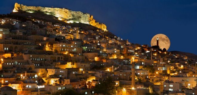
Mardin dendiğinde zihinlerde hemen o parıltı canlanır. Midyat evleri. Onlar sadece bina değil, tarihin taşından oyulmuş birer mücevher. Gece olduğunda ışıkla buluşunca adeta inci gibi parlar. Bu büyüleyici manzarayı görmek için Mardin merkezine takılmayın.
Oraya 1,5 saat uzaklıktaki Midyat’a doğru yola çıkın.
Neden Midyat’ı Seçmelisiniz?
Merkeze 90 dakika sürüyor. Bu yolculuk değiyor. Midyat’ın sokakları açık hava müzesi hissi veriyor. Ortaçağdan kalma tarihi yapılar sizi karşılıyor. Sıradan bir şehir ziyareti değil. Bir zaman makinesine binmek gibi.
Taş mimarisi insanı büyüler. Özellikle gece. Işıklandırma özenli. Evler ışıltıyla canlanıyor. “İnci” benzetmesi boşuna yapılmamış.
Görmeye Değer Olan Detaylar
- Ortaçağ atmosferi : Sadece fotoğraflık değil, hissediliyor.
- Gece ışıkları : Mimariyi vurguluyor. Siyah beyaz bir filmde yaşayan sokaklar.
- Konum : Mardin merkezine 1,5 saat uzaklık. Planlamayı buna göre yapın.
“Burada açık müzeyi andıran, ortaçağlardan kalma tarihi evleri andıran bu yapılar gece ışıklarıyla adeta bir inci şeklinde parıldarlar.”
Pratik Bilgiler
Yolunuz Mardin’e düşerse Midyat’ı es geçmeyin. Merkezden ayrılıp bu kasabaya yönelin. Taş evlerin büyüleyici yapısı sizi bekliyor. Gece vakti ışıklara vurduğunda o sihirli anı yakalamış olursunuz.


