Niğde küçük. Nüfusu 363.725 kişilik. Ama derinliği yüzeydeki sakinliğiyle orantısız. Milattan önceye uzanan bir geçmiş var burada. Sadece haritadaki bir nokta değil, katmanlı bir arkeolojik sahne. Turistler genellikle büyük kalabalıklı şehirlerde sıkışırken, Niğde gibi yerler sessizce bekliyor. Ve bu sessizlik, aslında konuşmak istiyor.
İşte Niğde’ye gitmeden önce bilmeniz gerekenler ve o kadar da bilinen olmayan gerçekler.
Niğde’nin Tarihçesi: Zamanın İzleri
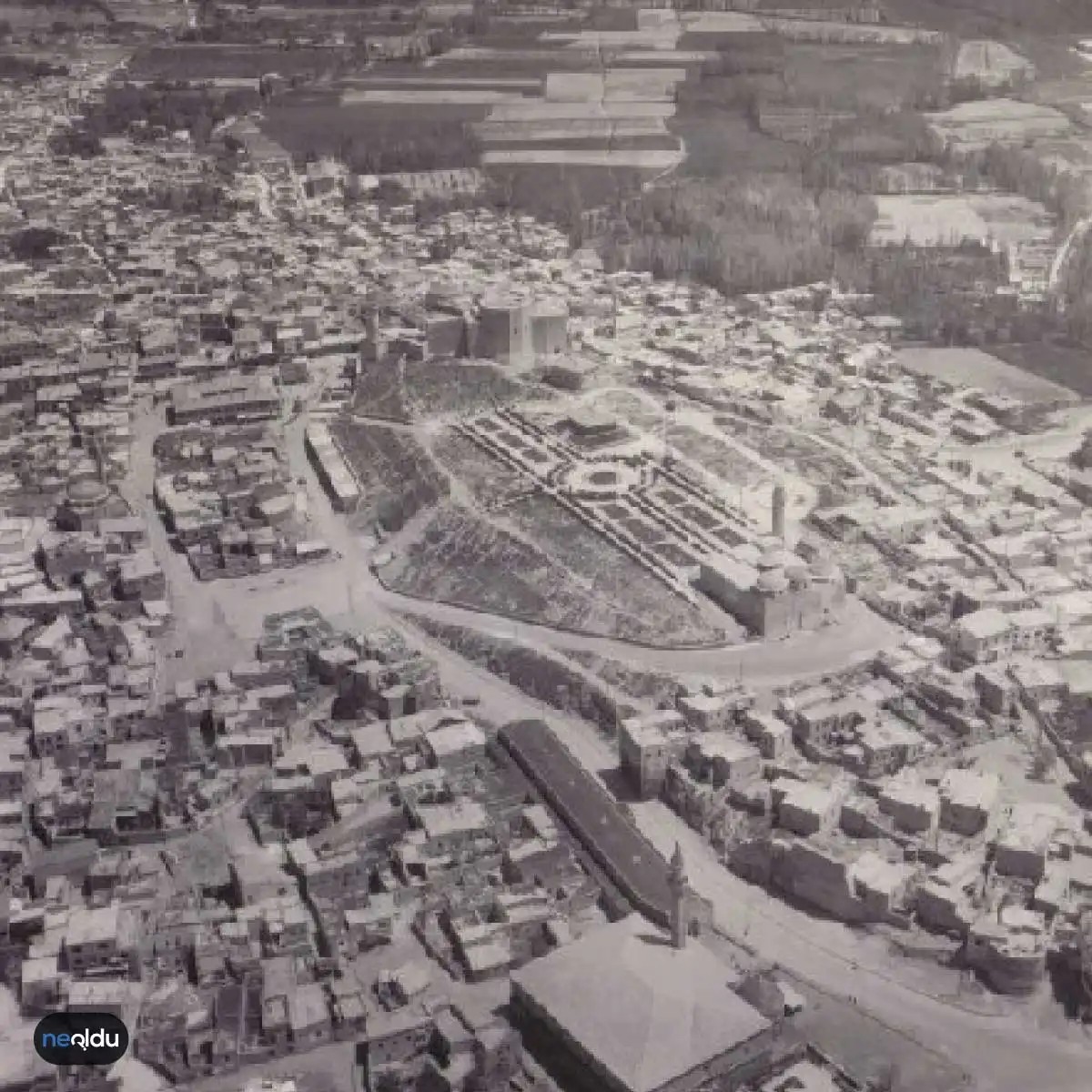
Tarih, burada toprağın altından değil, yüzeyinden okunur. Milattan önceye dayanan kökler, şehrin her taşına işlenmiş. Bu, sadece akademik bir not değil; sokaklarda, yapılarda, hatta atmosferde hissedilen bir gerçek.
Niğde Müzesi bu hikayenin kalbi. 2003 yılında Avrupa’da Yılın Müzesi’ne aday gösterilmişti. Evet, okursunuz. Küçük bir Anadolu kenti, Avrupa’daki en prestijli müze ödülüne aday olmuş. Bu durum, şehrin kültürel zenginliğini ve koruma çabalarını uluslararası arenada görünür kılmış. Bugün bile birçok turisti çekiyor.
Ama tarih sadece müze içinde kalmaz. Şehrin kaplıcaları da ziyaretçileri ağırlıyor. Tarih ve doğa burada kesişiyor. Eski medeniyetlerin izlerini sürerken, aynı zamanda iyileştirici suların arasında zaman geçirmek mümkün. Bu ikili, Niğde’yi diğer rotalardan ayıran kritik bir faktör.
Tarih, taşlarda değil, deneyimlerde saklıdır.
Niğde’de ne görmek? Hangi kaplıcalar tercih edilmeli? Hangi tarihi mekanlar mutlaka ziyaret edilmeli? İşte bu sorular, bir sonraki adımlarınızda yanıt bulacak. Ama önce, bu küçük şehrin neden bu kadar büyük bir mirasa sahip olduğunu anlamak gerekiyor.
Why Niğde’s weather changes everything about your trip
Pack for four seasons. Not because you’re staying a year. Because you might be there in July. And it gets cold. At night.
Niğde sits high. Like, really high. The average altitude hovers around 1,200 meters, pushing up to nearly 2,000 meters in the districts like Bor and Çamardı. This isn’t coastal humidity. This is continental. Sharp. Dry.
Summers are short. Hot days, yes. But the mountain breeze keeps it from becoming a sauna. You’re talking highs of 25-30°C during the day. Comfortable for hiking the volcanic trails near Erciyes Dağı. But once the sun dips? The temperature plummets. It can drop 10-15 degrees in an hour. Bring a jacket. Even in August.
Winters are serious. Snow isn’t a suggestion here. It’s a fact. Temperatures regularly dip below zero. The landscape turns white. The roads get icy. If you’re driving, chains might be your best friend. This isn’t a tropical escape. It’s a rugged, high-altitude winter wonderland. The air is crisp. Clean. Cold.
Spring and Autumn are fleeting. Beautiful, but short. April can bring rain and mud. October can bring early frost. These are the shoulder seasons. Fewer tourists. Cheaper hotels. But the weather is a gamble. You might get sunshine. You might get sleet.
Why does this matter? Because it dictates your itinerary. In July, you hike. In January, you stay in, drink tea, and look at the snow. Or you go skiing if the slopes at Erciyes are open. There’s no “perfect” weather. Just reality.
Most travelers underestimate the chill. They pack shorts and regret it by 8 PM. Don’t be that person. Layer up. The contrast between the scorching sun on the rocks and the biting wind in the valleys is part of the experience. It’s raw. It’s real.
How the landscape shapes the history you see
The land doesn’t just hold history. It creates it. Niğde’s geography is volcanic. Ancient eruptions left behind tuff stone. Soft. Easy to carve. This is why the rock-cut architecture exists. Why the caves remain.
The Erciyes Mountain dominates the view. It’s not just a peak. It’s a shield. It breaks the wind. It creates a microclimate. On one side, lush pastures. On the other, arid plains. This duality shaped the settlements. People built where the water was. Where the stone was soft.
You see this in the Hittite ruins. The Tabal region wasn’t chosen randomly. It was strategic. High ground. Defensible. The Bahçeli Köşk Höyüğü and Altunhisar Pınarbaşı Höyüğü aren’t just mounds. They’re testaments to survival. From 7000 BC onwards, people clung to these high points. Why? Because the valleys were dangerous. Floods. Invaders. The high ground was safety.
When the Romans arrived in
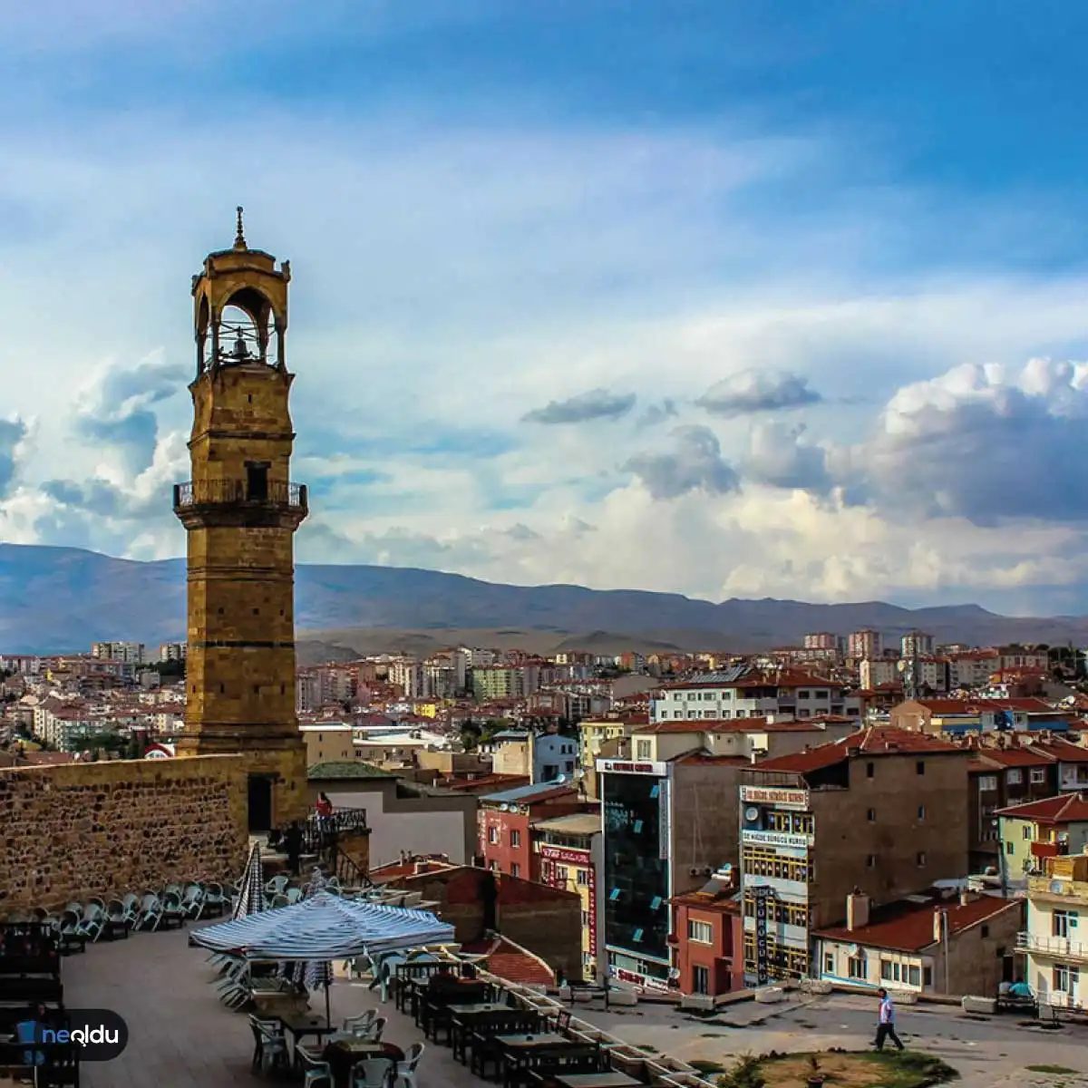
The brutal climate and surprising wealth of Niğde
Niğde doesn’t do gentle. It’s harsh continental weather, the kind that bites. Summers bake. Dry, relentless heat. Winters freeze solid. Snow piles up and stays. You’re looking at 100 days a year where the thermometer drops below zero. Thirty of those days see the city completely buried under white. If you’re planning a trip, check the calendar. July is the peak of the heat. January is the deep freeze.
Rain? Not much. The annual average sits at a modest 350 mm. Snow falls on about 15 days a year. It’s dry. It’s stark.
The landscape tells the story. Steppe grasses dominate. Only 1.7% of the land is forested. Think about that.
The rest is human effort or natural pasture. Half the land is cultivated. Fields stretch out, organized, productive. 37% is meadow and pastureland. The vegetation is sparse, adapted to survive the drought and the cold. It’s a landscape of resilience.
But dig beneath the soil. That’s where the real value hides. Niğde is poor in trees but rich in minerals. Seriously rich. We’re talking iron, zinc, lead, mercury, tungsten, copper, sulfur, silver, gold, antimony, kaolin, and gypsum. The ground is packed with it.
Yet, the money for most locals still comes from the dirt above. Agriculture rules here. And they’re good at it. Niğde ranks third in Turkey for apple production. Third. That’s impressive.
Potatoes? They’re number one. The undisputed potato capital of the country. If you eat Turkish potatoes, there’s a high chance Niğde had a hand in it. Legumes, sugar beets, garlic. The soil supports it all.
You might wonder, how does a place with so little rain grow so much food? It’s a mix of hardy crops and dedicated farming. The steppe environment demands efficiency. Waste nothing. Grow what survives.
Which brings us back to the geography. It’s not just flat fields. The terrain shapes the climate, which shapes the farming, which shapes the culture. It’s a loop. You can’t understand one without the other.
The contrast is jarring. One moment you’re looking at barren steppe, the next you’re reading reports of gold and silver reserves. It’s a place that hides its wealth underground while growing its livelihood above.
Why does this matter to a traveler? Because it explains the vibe. It’s not a soft, flowery destination. It’s grounded. Real. The food is heavy, hearty, rooted in the soil. The people are used to extremes.
When you see the apple orchards, remember the rank. When you eat the potatoes, remember the title. It’s not just food. It’s geography on a plate.
The weather will try to break you. The cold, the heat, the wind. But the land produces. Always.
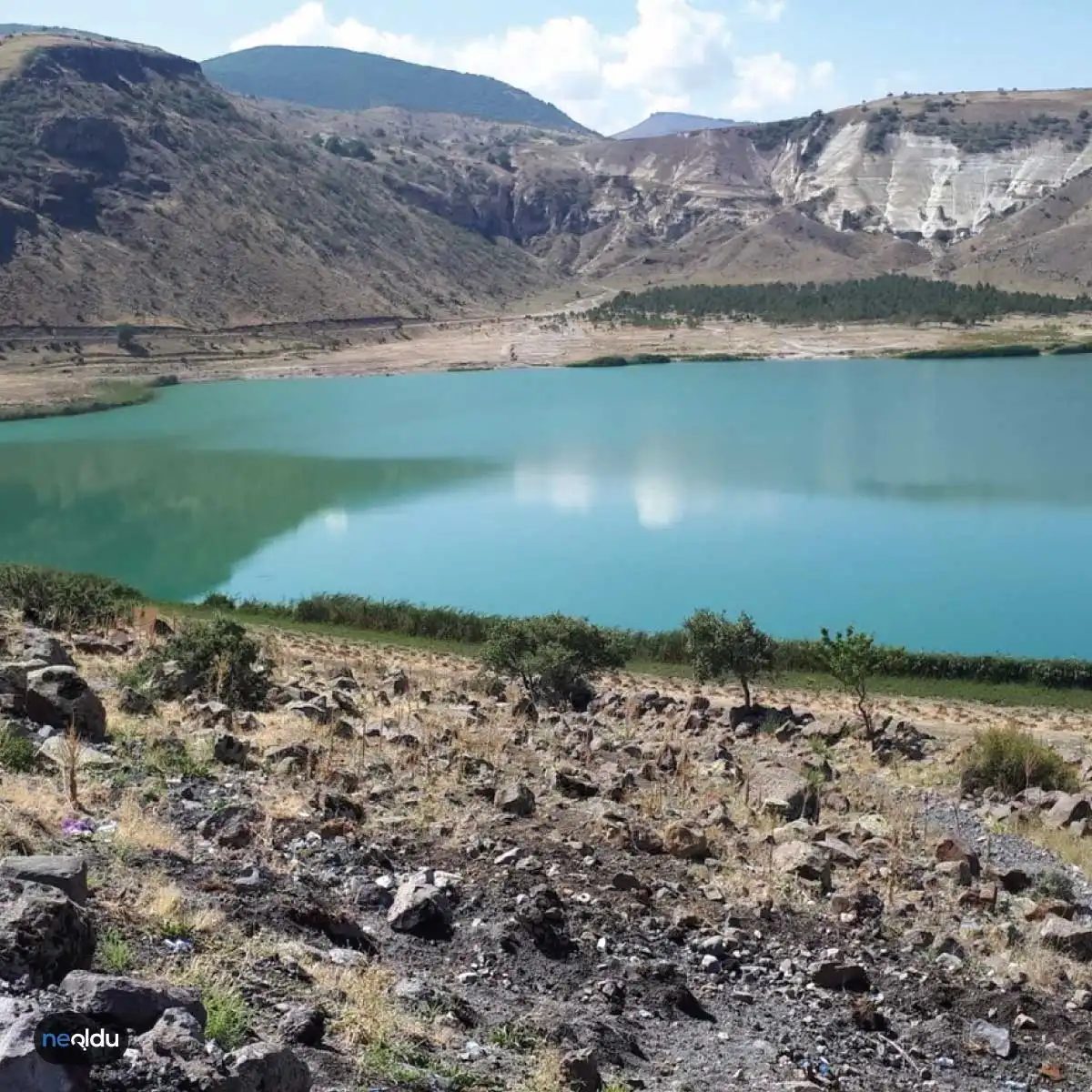
Where the mountains pinch and the valleys breathe
Niğde sits in the southeast corner of Central Anatolia. It’s a place defined by its cage. The young fold mountains of the Taurus range wrap around it on three sides. To the south and southeast, the Bolkar Mountains draw the line.
Look at the map. You’ll see it bordered by Nevşehir, Kayseri, Adana, Mersin, Karaman, Konya, and Aksaray. It feels isolated, maybe. But that isolation is the point. The city sits 1300 meters above sea level. The air is thinner here. Crisper. The province covers 779,522 square kilometers—roughly, depending on how you count the rugged edges.
The highest point isn’t a peak you climb for leisure. It’s Demirkazık Tepesi, reaching 3374 meters. It’s a landmark, not a postcard.
Most of the terrain is steep. Harsh. But there are pockets of flat land that matter. Misli Ovası, Melendiz Ovası, and Bor ovası are the green lungs. They are the flattest parts of the city. Also the most fertile. If you’re looking for where the food comes from, look there.
Water moves through the stone. The main arteries are Karasu, Çiftehan Çayı, Ecemiş Suyu, and Uluırmak. They don’t flow fast. They carve deep.
Niğde isn’t rich in lakes. Not like the west. But it has something better. Glacial cirque lakes. They formed when glaciers scraped the rock in the Aladağlar and Bolkar ranges.
“These aren’t swimming spots. They’re scars that filled with water.”
Akgöl. Alagöl. Çinigöl. Yedi Göller. Karagöl.
They sit high up. Cold. Clear. You drive up to find silence.
How to navigate Niğde’s districts and districts’ hidden layers
You can’t just visit “Niğde.” You visit its pieces. The districts hold the history. The weather changes by the hour as you move between them.
If you’re planning a trip, forget the generic itinerary. Start with the geography.
The Bolkar Mountains aren’t just a border. They’re a hiking destination. The trails are rough. The views are sharp. You don’t go there for comfort. You go because the rock formations look like they were torn from the earth yesterday.
Then there’s Bor. It’s not just an oval. It’s a mining town with a soul. The history there is buried in the ground—literally. But the landscape opens up. You can breathe easier in Bor.
Which lakes are actually worth the drive?
Don’t chase every blue dot on the map.
Akgöl and Alagöl are the most accessible. They sit in the Aladağlar. The drive is winding. The road surface can be poor. Take a 4×4 if you can. Or just drive slowly.
Yedi Göller —Seven Lakes—is a cluster. You don’t see them all at once. You hike between them. It’s a day trip, maybe two. The water is dark. Reflective
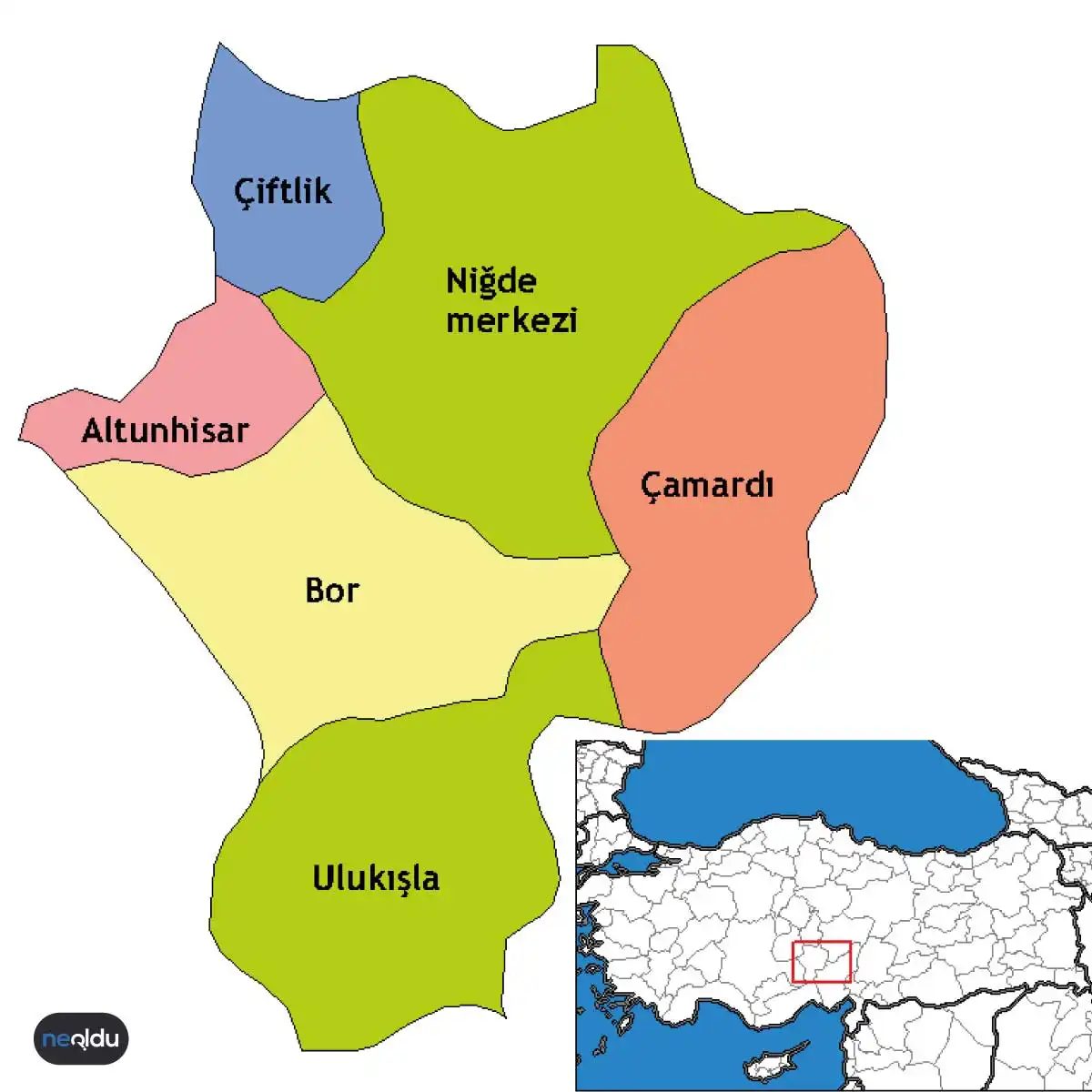

Which district is right for your Niğde itinerary?
You’ve got five districts to choose from. Altunhisar, Bor, Çamardı, Çiftlik, and Ulukışla. They aren’t just names on a map. They’re distinct vibes. If you’re driving through the central Anatolian plateau, the landscape shifts fast. One minute it’s flat wheat fields. The next it’s volcanic rock formations that look like something out of a sci-fi movie.
Most travelers stick to the city center. That’s fine. But the real character of Niğde lives in these outlying areas. Bor is famous for its ancient history and local cheeses. Çamardı is where the mountains actually start to bite. It’s colder there. Greener.
Don’t ignore them.
How do you identify Niğde on the road and phone?
Simple. Look for the number 51. That’s the license plate code. If you’re renting a car and need to report an incident, or if you’re just trying to spot other cars from the province, 51 is your marker. It’s unique to Niğde.
For phone calls, dial 0388. This is the area code for landlines. Yes, people still have landlines. Especially in the rural districts. If you’re booking a guesthouse in Ulukışla or a farm stay in Çamardı, that’s the number you’ll see. Write it down before you arrive. Signal can be spotty in the valleys.
What are the best ways to get to Niğde?
You don’t fly here. Not directly. The nearest airports are in Kayseri or Konya. Both are solid options.
Kayseri is closer. About two hours by car. The road is decent. You can rent a car there and drive up. The scenery changes as you leave the airport. Green turns to gold. The air gets drier.
Konya is further. Three hours or more. But the train station in Konya is historic. You can take a bus from there. Or a shared van. Dolmuşes are cheap. They’re packed. They stop everywhere. It’s an experience.
By car? The D400 highway connects Konya to Niğde. It’s straightforward. Boring, even. But it gets you there. If you’re coming from Ankara, you’ll pass through Kayseri first. Plan your stops. Eat in Kayseri. The kebabs are better. Then drive up.
By bus? Major companies run routes from Istanbul, Ankara, and Izmir. The terminal in Niğde is central. You’ll walk to most places. It’s not a huge city. That’s part of the charm.
The journey is half the fun if you stop looking at your phone and start looking out the window.
Which way do you prefer? Driving gives you freedom. You can pull over at any strange rock formation. You can stop for coffee in a village you’ve never heard of. Buses are passive. You sit. You watch. You sleep.
Both work. Both get you to Niğde. The question is how much control you want over the trip.