Algeria isn’t just a dot on the map. It’s a massive, overlooked giant sitting at the heart of North Africa. With nearly 40 million people spread across 2.38 million square kilometers, it holds the title for the largest country in Africa by land area. That’s a lot of space to get lost in. The capital shares the country’s name, simple enough, but the reality of traveling here is complex. It borders Tunisia, Libya, Niger, Mali, Mauritania, and Western Sahara. The geography shifts dramatically from the Mediterranean coast down into the heart of the Sahara. You’ll find ancient Roman ruins, Ottoman-era mosques, and French colonial architecture all mixed together. It’s not a place you visit for a quick photo op. You go for the depth.
The Green Heart of Algiers: Essai du Hamma Gardens
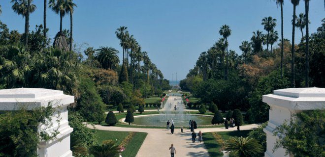
If you land in Algiers, your first breath of green will likely come from the Essai du Hamma Gardens. Located in the eastern part of the capital, this isn’t just a park. It’s a botanical museum with roots stretching back to the 19th century. Established originally by the French as a experimental agricultural station, it has since evolved into one of the most important botanical collections in the Mediterranean region.
Why should you care? Because Algeria is dry. Very dry. Finding a lush, curated space of exotic flora is rare. The gardens span roughly 30 hectares and house over 4,500 species of plants. You’re looking at trees and shrubs that have been adapted to this harsh climate over decades. It’s a study in survival and beauty.
The layout is distinct. You have the palm groves, the citrus orchards, and sections dedicated to specific families of plants like cacti or ferns. The air smells different here—earthy, humid, contrasting with the dusty streets outside. It’s a quiet escape. Most tourists rush past it to hit the Casbah or the Port Vieux. Don’t. Spend an afternoon here.
Logistically, it’s accessible. You can take a taxi from the city center, though prices can vary wildly if you don’t haggle. Alternatively, the bus system runs close by, but it’s chaotic for first-time visitors. Entry fees are nominal, usually a few hundred Algerian Dinars, making it a cheap way to decompress after dealing with the chaos of the capital.
The history adds weight. The gardens were damaged during the war for independence and have been carefully restored. Walking through them feels like walking through a living archive. You see the resilience of nature mirroring the resilience of the people who maintain it.
Are there other spots? Yes. The Jardin d’Essai du Hamma is often compared to the Jardin Exotique in Monaco or the botanical gardens in Cape Town, but with a distinct North African twist. The scent of orange blossoms mixes with the dry heat. It’s sensory overload in the best way.
You’ll want to bring water. It gets hot. Mid-morning is the best time to visit before the sun beats down too hard. Late afternoon offers softer light for photography, but the heat lingers. Bring your camera. The textures of the leaves, the architecture of the palm trunks, the shadows cast by the intricate irrigation channels—all
The Hidden Green Lung of Algiers: Jardin d’Essai du Hamma
Most travelers glide straight past it. They see a patch of green on the map of Algiers and assume it’s just another park. They are wrong.
Located in the Hamma district, near the National Gallery of Fine Arts, sits something entirely different. It is the Jardin d’Essai du Hamma.
A sprawling 58-hectare expanse of lush vegetation, this isn’t a manicured lawn for picnics. It is a living archive. Established in 1832 by French colonial authorities, the garden has served as one of the world’s most critical botanical testing grounds for nearly two centuries. If you are looking for quiet, or if you simply want to understand the botanical history of North Africa, this is where you go.
Why This Garden Matters
The scale of the operation is difficult to grasp until you walk through it. By 1834, the garden had introduced 25,000 plants. By 1837, that number had skyrocketed to 87,000.
Why so many so fast?
Because the garden became a central hub for global botanical acclimatization. Starting in 1842, it became a primary site for World Plant Climate Testing. Scientists used this specific microclimate to test how exotic species from around the globe could survive in Mediterranean and North African conditions.
Today, you are walking through the results of that massive experiment. The garden hosts thousands of exotic plant species. You will see annuals alongside long-lived perennials. Trees that shouldn’t survive this heat or that soil type do. It is a testament to botanical engineering.
What You Will See
Beyond the sheer volume of greenery, the garden is home to a surprising cast of residents. It is not just plants.
You will encounter:
– Llamas wandering near the arboretums
– Hedgehogs foraging in the underbrush
– Alpacas resting in the shade
– Various bird species that have adapted to the cultivated landscape
This mix of flora and fauna creates a unique atmosphere. It feels less like a museum and more like a sanctuary. For travelers seeking a break from the stone and concrete of the capital, the Jardin d’Essai du Hamma is a mandatory stop. It offers a depth of natural history that is rare in urban centers.
Ketchaoua Mosque

Why the Ketchaoua Mosque Matters More Than Its Architecture
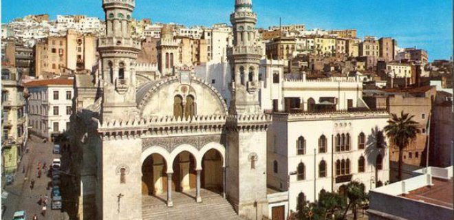
It sits in the capital, Cezayir, looking every bit the monument it claims to be. You walk up to it and see the blend of Byzantine structure with Maghrebi detailing—a marriage of styles that shouldn’t work but does. The Ketchaoua Mosque opened its doors in 1612. For centuries, it has been the face of the country. You see it in brochures. You see it in history books. It is the most impressive Ottoman structure to survive in the region.
But the stone tells a darker story than the minaret ever could.
When the French invasion hit the area about 220 years later, they didn’t just want the land. They wanted to erase the past. The plan was simple. Turn this sacred space into a cathedral. It was a power move disguised as urban planning. The locals didn’t take kindly to the idea.
About 4,000 Algerians were executed by burning for resisting the conversion of the mosque.
Think about that number. Four thousand people. Alive. Burned. Because they stood in front of a building and refused to let it be changed. That wasn’t a protest. It was a massacre. The square where the mosque stands isn’t just a plaza anymore. It’s a wound. After independence, they named it Martyrs’ Square. The name sticks. It reminds you of what happened there.
This is why visiting isn’t just about sightseeing. It’s about understanding the weight of that stone. You come for the Ottoman grandeur. You leave with the memory of the blood on the pavement.
Maqam Echahid (The Martyrs’ Memorial)
The Martyrs’ Monument: A Concrete Palm Over Algiers
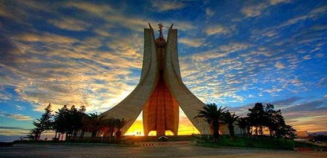
It took twenty years for the wounds to close enough to build a monument. That’s why the Martyrs’ Monument (Mémorial du Martyr) wasn’t erected until 1982. It stands over Algiers like a massive, concrete palm frond reaching toward the sky. You can see it from miles away. It’s not subtle. At 92 meters tall, it dominates the skyline.
The design came from the Algiers Institute of Fine Arts. The actual heavy lifting—the concrete structure—was handled by a Canadian firm. They built it to look like the leaves of a date palm, a symbol of resilience. Along the walls, you’ll find statues of soldiers. They aren’t just decoration. They represent the face of the Algerian War of Independence.
Visiting here is less about sightseeing and more about feeling the weight of history. It’s one of those places that demands you stop and look up. The scale is aggressive. The intent is clear. It’s a reminder of the cost of sovereignty.
Bardo Prehistoric and Ethnographic National Museum
The Bardo’s Ancient Echoes
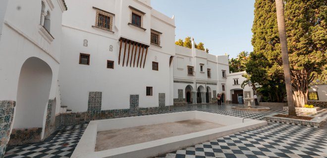
You’re standing on Avenue Franklin Roosevelt in Algiers. The traffic is loud, the heat is heavy, but the Bardo National Museum of Prehistory and Ethnography sits there, quiet and imposing. It opened in 1928. But the land? It has been a settlement hub since the Neolithic era.
This isn’t just a museum. It is a time capsule.
Inside, you aren’t looking at vague artifacts. You are staring at actual pottery shards and rock carvings. These pieces date back to the earliest days of human habitation in Algeria. The museum does what few others can: it bridges the gap between prehistory and ethnography. You see the tools. You see the art. Then you walk further in and see how those early cultures evolved into the societies we know today.
It hosts rotating art exhibitions too. This keeps the space alive. It isn’t just dusty relics behind glass. It’s a living gallery. For many visitors, this makes it the most tourist-friendly spot in the city. Why? Because it answers the big question. How did Algeria begin? The answers are here.
*** Notre Dame d’Afrique ***
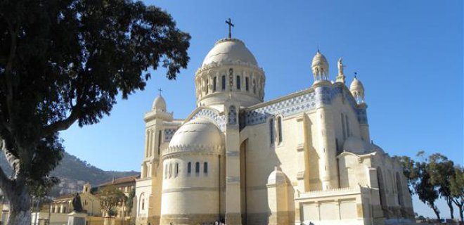
Start with the skyline. Look past the chaotic traffic and the white-washed buildings climbing the hillsides to catch the glittering dome. That is the Basilica of Our Lady of Africa, a structure that defines the capital’s spiritual and architectural identity. It is not just a church. It is a survivor.
Construction began in 1872, but there is a discrepancy in the dates. Some sources say it opened in 1858. Others stick to the later completion. The truth lies somewhere in the messy timeline of colonial ambition. Architect Jean Eugene Fromageau designed it in a bold Neo-Bizantine style. Think massive domes, intricate mosaics, and a sense of grandeur that demanded attention. It was built to be the heart of the Roman Catholic community in Algeria.
Then came the war.
1943 changed everything. Allied bombing raids devastated the city. The basilica took a direct hit. The damage was severe. Specifically, 46 stained-glass windows were shattered. The mosaics cracked. The structure groaned under the weight of the explosions. It looked like a ruin.
But it did not stay that way.
Two major restoration projects brought it back. The first was immediate. The second came later, preserving the integrity of the original design. Today, the light filtering through the restored glass is soft. Golden. Peaceful.
Why does this matter for your itinerary? Because it sits right by the port. You can walk there from the old city. You can see it before the sun sets. It is a tangible reminder of the layers of history in Algiers. French colonial rule. War. Reconstruction. Modern Algeria.
A Walk Through History
The location is strategic. It overlooks the Bay of Algiers. The views are expansive. You can see the ships docking. You can see the city stretching out behind you.
Timing matters here. Go early. The light is better. The crowds are smaller. The heat is manageable. Afternoon tours can be stifling.
What to look for inside. The mosaics. They are intricate. They depict religious scenes. But they also reflect the artistic trends of the late 19th century. The architecture is heavy. The columns are thick. It feels solid. Immovable.
Is it worth the visit? Yes. It is one of the key landmarks in Algiers. It offers a moment of quiet. A chance to reflect on the resilience of the building. And the city that surrounds it.
Afterwards, the air changes. The humidity rises. The city hums with life. You need to move. You need to breathe.
El Kala National Park
El Kala National Park: A Wildlife Sanctuary You Can’t Afford to Miss
If you head to the northeast corner of Algeria, the landscape shifts. You are looking at 800 square kilometers of protected wilderness. This isn’t just a park. It is the El Kala National Park. The area holds a unique position in the Mediterranean basin. The ecosystem here is unlike anything else in the region. It features a complex web of lakes and wetlands. In 1990, UNESCO recognized this significance. They declared the zone a biosphere reserve. The designation stuck.
The biodiversity here is dense. You are walking through habitat that supports 40 mammal species. Birds dominate the skies. There are 25 species of game birds. Freshwater habitats host 64 types of waterfowl. Marine environments add another nine seabird species. The deer population is particularly strong. They are the most abundant animal in the park. But not everything is thriving. Some plant and animal species face extinction threats. This makes conservation efforts critical for visitors who respect nature.
For travelers planning a trip to Algeria, this stop is non-negotiable. It is the premier destination for nature lovers. You come here to see what remains of untouched North African wilderness. The logistics are straightforward but require planning. The park is remote. You need to account for travel time from major hubs.
Why El Kala Deserves a Spot on Your Itinerary
Most tourists skip the northeast. They stick to the coast or the Sahara. This is a mistake. The El Kala National Park offers a different kind of Algeria. It is green. It is wet. It is loud with bird calls.
The UNESCO status isn’t just a plaque on a wall. It means stricter protections. It means better-maintained trails in some areas. It also means fewer crowds. You can actually hear yourself think. Or at least, hear the birds. The combination of freshwater and marine ecosystems creates a buffer zone. This buffer supports a high density of wildlife.
Deer are easy to spot. They graze in the open plains. Keep your eyes on the tree lines. The rare plants and animals are harder to find. You might need a guided tour to spot them. Local guides know where the endangered species hide. They also know the safe paths. Venturing off-trail risks disturbing fragile habitats. It also risks getting lost. The terrain can be deceptive. Mud and reeds make footing tricky.
Practical Tips for Visiting the Northeast
Getting there requires effort. The park is far from Algiers. You can fly into Annaba. From there, it is a drive inland. Renting a car is the best option. Public transport is sparse. Buses might not go all the way to the park entrance. You will likely need a taxi or a hired driver for the final leg.
Timing matters. Spring and autumn are ideal. Summer brings heat and insects. Winter can be wet and muddy. Pack accordingly. Waterproof boots are a must. The wetlands are exactly what they sound like. Water everywhere. Bring binoculars. The birdwatching is world-class. If you are serious about photography, bring a telephoto lens. The animals are shy. Getting close requires patience.
Costs vary. Entrance fees are generally low. But guided tours cost extra. These guides are worth the money. They provide context. They point
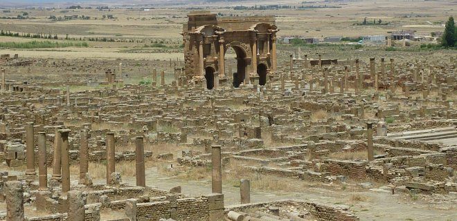
Aures Dağları’nın eteklerinde, çölün sıcaklığı hâliyle hissedilirken durur Timgad. Batna ilçesinden yaklaşık 35 kilometre doğuda, sessizlik içinde yankılanan bir tarih. MS 100 yılında İmparator Trajan tarafından askeri bir koloni olarak kurulan bu antik kent, Roma şehir planlamacılığının en özgün örneklerinden biri olarak hâlâ ayakta.
Roma Şehir Planlamacılığının En İyi Örneklerinden Biri
Timgad’ı neden görmeniz gerektiği sorusunun cevabı, düz çizgilerde saklı. Şehir, dikdörtgen bir izgara sistemi üzerine kurulmuş. Cezayir’deki en iyi korunmuş Roma kalıntılarından biri olması boşuna değil.
Nüfusunun yaklaşık 15 bin kişilik bir grup için tasarlandığı düşünülüyor. Bugün ayakta kalanlar, o dönemin disiplinini ve lüksünü gösteriyor.
- Tarihi Sütunlar: Yıkık görünümleri kadar, duruşları da etkileyici.
- Surlar: Şehrin sınırlarını çizen bu duvarlar, hâlâ koruma görevini yapıyor.
- Diğer Yapılar: Tiyaatrolar, hamamlar… Hepsi, bir zamanlar buranın ne kadar canlı olduğunu fısıldıyor.
Cezayir’in tarihi yerler arasında Timgad, kendine özgü bir yere sahip. Çünkü burası sadece bir harabe değil. Bir şehir planı.
Nereye Gideceğinizi Bilin
Cezayir Modern Sanat Müzesi’ne geçmeden önce, Timgad’daki bu durağı ihmal etmeyin. Tarih ve modernite arasında gidip gelen bir seyahat planı, Cezayir’in çok katmanlı kimliğini daha iyi anlammanızı sağlar.
Timgad’a giderken, otobüs veya özel araç seçeneklerini değerlendirin. Batna’dan kalkan servisler düzenli olabilir, ama esneklik isterse araba daha iyi. Hava koşullarına dikkat edin. Yazın sıcaklık yükselebilir.
Cezayir Modern Sanat Müzesi
Timgad’dan sonra, gözleriniz modern bir yere dönecek. Cezayir Modern Sanat Müzesi. Burada tarihi taşlar değil, fırça darbeleri var. Müze, Cezayir’in bağımsızlık sonrası sanat akımlarını barındıran önemli bir merkez.
Timgad’ın sessizliğiyle müzenin dinamizmi arasında bir geçiş. Hangi sanatı tercih edersiniz? Taş mı, kanvas mı?
Cezayir’de seyahat etmek, bu tür zıtlıklarla dolu. Her durak, farklı bir hikâye anlatıyor. Timgad, Roma’nın izini sürerken. Müze, modern kimliğin peşinde.
B
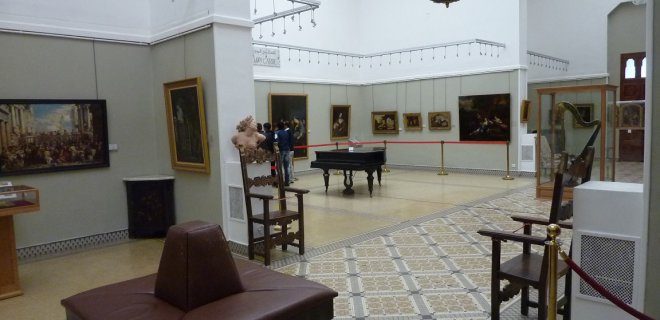
The Mamoud Museum: Where Modern Algerian Art Lives
Locals don’t bother with the full formal name. They call it MaMa. The Mamoud Museum of Modern and Contemporary Art might sound like a nickname born of convenience, but it carries weight. It sits inside a building that has seen more than a century of history. Constructed between 1901 and 1909, the structure itself is a relic. Since 2007, it has functioned as a gallery.
The collection is not an afterthought. It houses works by heavyweights of Algerian modernism. You will find paintings and sculptures by Olivier Debre. You will walk past pieces by M’Hamed Issiakhem. These are not background decorations. They are central to understanding the country’s artistic pulse.
Thousands visit every year. If you are planning a trip to Algiers, skipping this is a mistake. The intersection of colonial-era architecture and post-independence modernism creates a specific atmosphere. It is intense. The lighting in the galleries is often low. The shadows lengthen over the canvases. You feel the history in the walls.
“The museum is a vital touchstone for understanding Algeria’s cultural identity through its visual arts.”
Why the MaMa Matters
The museum does not just display art. It preserves a narrative. After independence, Algeria needed to define itself visually. The MaMa became that canvas. It houses a diverse range of mediums. Some pieces are large-scale canvases. Others are intimate sketches. The variety prevents fatigue.
Which artists are most prominent?
- Olivier Debre : Known for his vibrant use of color and abstract forms. His work dominates several key galleries.
- M’Hamed Issiakhem : A figure whose work bridges abstraction and figuration. His pieces often carry a raw, emotional intensity.
The museum also features sculpture. These works break the flat plane of the canvas. They occupy space. They demand you move around them. This physical engagement is what makes the visit memorable. You are not just looking. You are navigating.
Logistics for the Traveler
Getting there is straightforward. It is located in the heart of Algiers. You can walk from many central hotels. If you take a taxi, specify the address clearly. The building is historic. It has a distinct presence on the street.
When is the best time to visit?
Morning light hits the building’s facade. It creates a sharp contrast with the darker interior. This makes for good photos if you are capturing the exterior. Inside, natural light is controlled. This protects the artworks. It also creates a quiet environment.
Is it worth the entry fee?
Yes. The entry fee is modest. The value is in the curation. You are seeing works that are rarely exported. You are seeing the core of modern Algerian art. For a traveler, this is authentic. It is not a tourist trap. It is a serious institution.
Beyond the Paintings
The building itself deserves attention. The architecture from the early 1900s offers a glimpse into a different era. The arches. The stone work. The way the space flows from one room to another. It mirrors the transition in the art itself. From traditional forms to modern expressions.
Some galleries feel
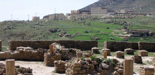
You’re standing at 1,418 meters. The air is thinner here. Colder, too.
This isn’t just another ruin. It’s the skeletal remains of an empire. Qal’at Bani Hammad sits in the Babors Mountains of northern Algeria, overlooking a landscape that feels ancient before you even step onto the stones. For decades, this was the first capital of the Hammadid dynasty. Then, in 1090, they abandoned it. The next dynasty moved on. And the city was left to the wind.
UNESCO called it an “authentic Muslim city” when they added it to the World Heritage list in 1980. That’s not just bureaucratic paperwork. It’s a description of a place where Islamic urban planning was still being written in real-time.
Why should this be on your itinerary? Because it’s hauntingly beautiful. And because it’s rarely crowded.
The Scale of Abandonment
The city walls are massive. Seven kilometers long. They still stand, mostly, wrapping around the ruins like a protective embrace. Walking those walls gives you a sense of scale that photos can’t capture. You’re not looking at a single palace. You’re looking at a metropolis that once held thousands.
The architecture is distinct. You’ll see remnants of palaces, mosques, and residential quarters scattered across the plateau. It’s not neat. It’s not restored for comfort. It’s raw history.
“Qal’at Bani Hammad is one of the most valuable historical cities in the Islamic geography.”
This isn’t hyperbole. It’s one of the few well-preserved examples of a 11th-century Islamic capital in North Africa. Most others are buried or completely rebuilt. Here, you can touch the stones.
How to Get There
It’s not a quick hop from Algiers. You’re looking at a drive of about four to five hours depending on your starting point and road conditions. The roads through the mountains can be winding. But the views compensate. You’re cutting through the Atlas Mountains, seeing villages that haven’t changed much in centuries.
- From Algiers: Take the eastbound highway toward Tizi Ouzou, then head south toward Bejaia. From Bejaia, you’ll need to head inland toward the mountainous region.
- Best Time to Visit: Spring or autumn. Summers can be hot in the valley, though cooler up here. Winters bring rain, which can make the mountain roads slippery.
- Logistics: Public transport is limited. Hiring a car with a driver is the most reliable option. You need flexibility. You need to stop for photos. You need to understand the terrain.
What to Actually See
Don’t just walk around aimlessly. The site is large. Focus on the key structures:
- The Palace Complex: Look for the foundations of the main palace. The layout gives you a sense of how the Hammadid rulers lived—open, connected to the landscape, but fortified.
- The Mosque: The central mosque’s minaret base is still visible. It’s a reminder of the religious heart of the city.
- The City Walls: Walk a
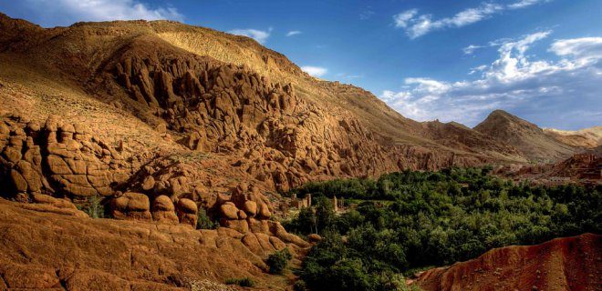
The High Atlas: A Vertical Challenge
The Atlas Mountains don’t just sit on the map. They carve it. Stretching 2,400 kilometers from Algeria through Morocco, this range is a geological spine that defines North Africa. The area spans over 775,000 square kilometers. The highest peaks punch through at 4,165 meters.
It’s not for the faint of heart. The vegetation is sparse, clinging to life in harsh conditions. The valleys, however, are stunning. Deep gorges cut through the rock. The views are stark, majestic, and relentless.
Travelers don’t just pass through here. They plan trips specifically to see them. Climbers flock to the high points. It’s one of Algeria’s top tourist draws for a reason. The altitude demands respect. The scale demands awe.
Mzab Valley
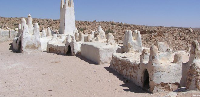
The M’zab Valley isn’t just a spot on a map. It is a limestone plateau in northern Algeria, tucked away in the Ghardaia Province. You walk through here and the landscape shifts. The rock formations are stark. But the real story lies in what humans built on top of it.
The architecture here doesn’t just sit there. It fuses with the desert. It creates a specific kind of harmony between nature and habitation. The valley connects five historic settlements. They were designed to withstand the harsh climate and potential conflicts. This isn’t accidental urban planning. It is survival shaped into a community.
UNESCO recognized this in 1982. They added it to the World Heritage List. Why? Because it is a unique example of Ibadi Muslim society. It stands as a model of early urban adaptation. The valley is not just important for the Arab world. It matters for all of humanity. If you are planning a trip to Algeria, this needs to be on your list.
Why the M’zab Valley Is Unmissable
You might wonder what makes this place different from other desert towns. Most settlements here were built for defense. The layout reflects that. The mosques are central. The houses are stacked close together. This provides shade. It also makes it harder for invaders to get in.
The five main villages are Ghardaia, Béni Isguen, Melika, Bounoura, and El Atteuf. Each has its own character. Ghardaia is the largest. It feels like the capital of the valley. The other towns are smaller. They are quieter. They offer a different pace.
Travelers often ask how to get there. You fly into Algiers. Then you take a domestic flight or a long bus ride south to Ghardaia. The journey is part of the experience. The landscape changes from Mediterranean coast to deep Sahara. The drive takes time. Be patient. The isolation adds to the atmosphere.
What to See and Do
The architecture is the main draw. The white-washed houses contrast with the red earth. The narrow streets are shaded by awnings. You can climb the minarets for views. The perspective from above changes how you see the valley. It looks like a network of islands in a sea of sand.
Visit the museums in Ghardaia. They hold artifacts from the region. You learn about the Ibadi community. Their history is rich. It dates back centuries. The cultural museum is small. But it packs a punch. It explains the daily life here.
The markets are worth a visit too. You can buy textiles. Local crafts are available. The prices are reasonable. Bargaining is expected. It is part of the interaction. Don’t be shy. Engage with the locals. They are used to travelers. But respect their customs. Dress modestly. This is a conservative region.
The M’zab Valley is a testament to human resilience. It shows how we can adapt to extreme environments without losing our cultural identity.
Practical Tips for Your Visit
Timing matters. Summer is brutal. Temperatures soar. Avoid July and August. The best time to visit is spring or autumn. The weather is mild. You can walk around comfortably. Mornings are cool. Evenings can get chilly. Pack layers.
Accommodation is limited. There are guest