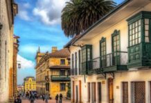
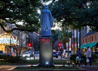
Chile is a geographic anomaly. It lies between the Pacific Ocean and the Andes, a narrow strip of land that defies easy categorization. In an area of 756,950 square kilometers with a population of about 17.5 million, the land is dense in some areas, and vast in others. Its length is breathtaking – 4300 kilometers from north to south. This makes it one of the most climatically diverse countries in the world. You can go from dry desert to temperate rainforest without crossing a border.
The width is a different matter. On average, the country is only 180 kilometers wide from east to west. Thanks to this narrow profile, Chile does not have to contend with multiple time zones like its neighbors. The capital, Santiago, is located in the middle of the country’s largest population center. It is a center of history, culture and tourism. When planning a trip, the first stop is almost always the south. Especially the wild, windswept heart of Patagonia.
How to hike in Torres del Paine National Park
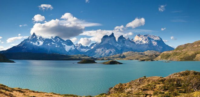
You can’t talk about tourism in Chile without mentioning Torres del Paine National Park. It’s not just a park. It is a prehistoric landscape. The Andes in the very south meet the steppe. The name means “blue towers” and refers to the granite towers that dominate the skyline.
Why do travelers go there? The hiking trails are world class. The “W” circuit is the most popular option. Completion takes about four to five days. You will hike past turquoise glacial lakes, huge ice fields and waterfalls that tumble into deep valleys. Torres del Paine National Park is a UNESCO Biosphere Reserve, but it feels more like a harsh, untamed frontier.
Logistics is important here. The best time to travel is the southern summer from November to March. The weather is mild and the days are long. Winter brings snow, ice and short daylight hours. If you’re traveling in the off-season, be aware of the wind. It can throw you off balance.
Getting there requires planning. You fly to Punta Arenas or Puerto Natales. It is a two-hour bus ride from Puerto Natales to the entrance of the park. Inside, you must reserve refugios (mountain lodges) or campsites months in advance. During the high season, they are sold out immediately. Costs are increasing rapidly. A basic bed in a shared cabin can cost between $50 and $100 per night. Food is expensive. Bring snacks. There are only a few shops in the park.
The granite towers themselves require an extra day of hiking. It’s steep. It’s exhausting. But standing at the foot of these blue towers at sunrise changes the way you see the mountains. It’s not just sightseeing. It’s a physical challenge that rewards you with views that most people only see in photographs.
Outside the towers, Gray Glacier is a spectacle. Ice calving in a lake sounds like a shot. The silence that follows is heavier. This is the kind of place that will make you rethink your travel plan. Maybe you want to stay longer. Maybe you don’t want to do anything
Torres del Paine National Park
If you are planning a trip to Chile, Torres del Paine National Park is not just a stop on your itinerary; that’s the goal. This huge reserve is located in the Patagonia region and covers about 2,400 square kilometers. Protected since 1959, the park’s name comes from its most iconic feature: three towering granite towers that reach into the sky like jagged fingers. They are unmistakable.
The landscape here is wild and unforgiving. You can see glaciers on mountains that are more than 3000 meters high. It is a mecca for climbers. For everyone else, it’s a place where the air feels thinner and the silence heavier. Biodiversity is as impressive as geology. Look out for shy cougars, giant Andean condors circling overhead and gray Patagonian foxes scurrying across the meadows.
“The park should be one of the first stops on any trip to Chile.”
Visiting Torres del Paine National Park requires planning. Routes range from simple circular routes to multi-day hikes such as the W or O track. The weather changes dramatically; You can experience four seasons in one afternoon. Pack layers. Book accommodation well in advance, especially during the Southern Hemisphere summer (December to February), as spots fill up months ahead.
Lauca National Park
As we move north, the landscape changes drastically. Lauca National Park is located high in the Andes on the Bolivian border. This is not the fjord-covered coastline of Patagonia. These are high deserts, volcanic peaks and vast wetlands with a completely different ecosystem.
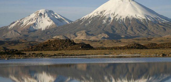
Lauca National Park: A high-altitude biosphere reserve
Head to the northernmost tip of the country to Lauca National Park, a landscape that feels less like an ordinary nature reserve and more like otherworldly moonscape. It was officially declared a national park in 1970, but its global significance goes back even further. It has been recognized by UNESCO as a biosphere reserve, a designation that protects the delicate interaction between the extreme altitude and the unique flora and fauna that live there.
The park covers a huge 1,379 square kilometers of rugged terrain. If you’re planning a trip here, you need to be prepared for the altitude. This is not a place for the faint of heart. The area is dominated by volcanic peaks, some of which are over 6,000 meters high. Thin air is a constant companion.
In the heart of this high Andean landscape lies Lago Chungara. It is one of the highest lakes in the world and is almost 4,500 meters above sea level. The water is ice cold and reflects the snow-capped volcanoes that tower overhead. It is a stark, beautiful contrast to the dry, reddish soil that surrounds it. Visitors often come here to see the Andean flamingos, whose bright pink bodies stand out against the muted earth tones. Getting there requires steep, winding roads, so the travel time is longer than shown on the map. Allow extra time for acclimatize. The reward is a view of nature in its most pristine form, untouched by urban development.
Palacio de La Moneda
Just a short distance from the Highlands, Santiago is the political heart of the nation. Palacio de La Moneda serves as the seat of the president of Chile. Its neoclassical architecture is impressive, and its facade resembles a Greek temple more than a modern administrative building. The name ” La Moneda “means” Mint ” and refers to its original purpose when it was built in the 18th century.
Today it is one of the capital’s most popular landmarks. You can explore the interior to understand the history of Chilean governance, from colonial times to modern democracy. The courtyard is often open to the public and provides a quiet space in the middle of the busy city centre. It’s a place where history is palpable, especially given the building’s role in the political upheaval of the 20th century. For travelers interested in political history, guided tours offer important information you won’t find in any guidebook. The surrounding square is always filled with a gathering of street artists and locals, making it a lively place to observe Santiago’s daily life.
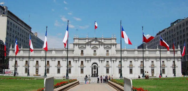
Inside Santiago’s Presidential Palace
Dominating the central square of Santiago is Palacio de La Moneda, the official residence of the President of Chile. It is not just a building; it is the symbolic anchor of the capital. If you are looking for a place that defines the city’s political and architectural soul, this is it.
The structure’s origins are surprisingly sophisticated for its time. Designed by the renowned architect Joaquin Toesca, construction began in 1784 and was not fully completed until 1805. Toesca, an Italian architect who spent much of his career in South America, brought a neoclassical elegance that stood out against the colonial backdrop of the era.
For over a century, it served as the primary residence for Chile’s heads of state. However, its role shifted in the mid-20th century. By the second quarter of the 1900s, the palace ceased to be the President’s home, transitioning into a pure administrative center. This change marked a significant shift in how the building was used, though it retained its ceremonial weight.
The building has seen its share of turbulence. A comprehensive restoration in 1981 was necessary to preserve its structural integrity and historical accuracy. Following this renovation, the doors opened wider to the public. Today, it is one of the top sights in Chile, offering visitors a chance to walk through halls where national history was made.
Walking through La Moneda is less about seeing a museum and more about understanding the weight of the office it houses. The architecture is stately, but the atmosphere is charged with history.
Practical Details for Visitors
- Location: Plaza de la Ciudadanía, Santiago Centro. It is easily accessible from most central hotels.
- History: Built between 1784 and 1805; restored in 1981.
- Architect: Joaquin Toesca.
- Key Feature: Neoclassical design with a prominent central dome.
- Status: Official residence of the President, but open for public tours in specific areas.
The tours usually cover the main reception rooms and the courtyard. While you won’t find the President’s private quarters on display, the public spaces offer a glimpse into the grandeur expected of a national palace. The contrast between the marble floors and the modern security presence is striking.
Museo Chileno de Arte Precolombino
Just a short walk from the palace lies another cultural heavyweight: the Museo Chileno de Arte Precolombino (Chilean Museum of Pre-Columbian Art). This institution is dedicated to preserving and showcasing the artistic heritage of the Americas before the arrival of Columbus.
The museum houses an extensive collection of artifacts from various pre-Columbian civilizations, including the Inca, Maya, and Aztec, as well as cultures from the Andes and Amazon regions. The collection is not just static; it is curated to tell a story about the diversity and complexity of these ancient societies.
Visitors can expect to see intricate pottery, textiles, jewelry, and ceremonial objects. The lighting and presentation are modern, allowing the artifacts to speak for themselves without distraction. It is a place where
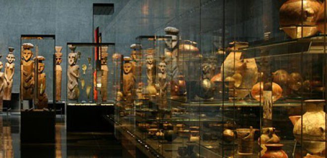
The National Museum of Fine Arts in Santiago is not just about painting and sculpture. If you look closely at the collection, you will find one of the most important Pre-Columbian art displays in Central and South America. Since its opening in 1981, this institution has become one of the most popular cultural centers in the country.
It’s located in a place that practically demands your attention: the Palacio de la Real Aduana. Built between 1805 and 1807, this building is a work of art in itself. Today it anchors the Plaza de Armas, Santiago’s most famous square. Stepping into this historic structure feels like stepping back into colonial times, and you’re greeted by artefacts dating back thousands of years.
What Pre-Columbian Artifacts Should You See?
The museum’s strength lies in its scope. You don’t just see pottery shards. You will encounter intricate sculptures, intricate textiles and ceremonial objects from different Andean cultures. These pieces tell the story of civilizations that flourished long before European contact.
Visitors often ask how to navigate this section. Start with the Andean collections. The textiles of the Paracas and Nazca cultures are particularly striking. The colors used are still bright even after thousands of years. Geometric patterns on fabrics are not only decorative; They are a language in themselves.
The museum offers more than just an exhibition of objects. It contextualizes them. You can see how trade routes connected distant places. You can see how religious beliefs affected everyday life. This is not a static exhibition. It is a story of human ingenuity and spiritual depth.
Why visit the National Museum of Fine Arts?
In addition to the pre-Columbian section, the museum offers a more comprehensive artistic journey. However, for many tourists, the ancient objects are the main attraction. They offer a tangible connection to Chile’s deep history. This history is often overshadowed by the country’s modern wine tourism or its dramatic landscapes.
The location of the building is decisive. After exploring the museum, you can go to the Plaza de Armas. The contrast between the colonial architecture and the ancient artifacts inside creates a unique cultural experience. It’s not just a museum visit. It is a immersion in the layers of Chilean identity.
Chiloé: A different heritage
If you’re interested in heritage outside of museums, check out the islands. Chiloé offers a unique cultural landscape. The area is known for its wooden churches, many of which are UNESCO World Heritage Sites. These structures are built entirely of wood and use techniques passed down from generation to generation.
Churches are not only religious places. They are symbols of resilience. They reflect a mixture of indigenous and Spanish influences. A visit to Chiloé requires more planning than a trip to Santiago. This includes ferry trips and longer car journeys. But the experience is worth it. The architecture differs sharply from the stone and brick of the mainland.
The contrast between the objects in the museum and the living heritage of Chiloe is interesting. The past is kept in glass cases. The other lets it breathe in the rain and wind of the Pacific coast. Both are important to understanding the full scope of Chilean culture.
Practical tips for your visit
- Timing: Plan your visit during the week. Weekends are crowded.
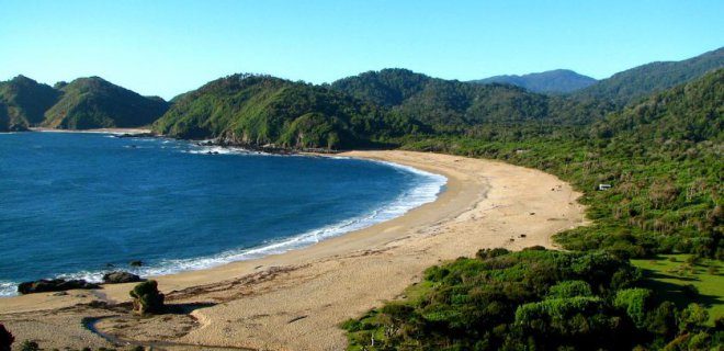
At almost 8,400 square kilometers and 180 kilometers long, the island of Chiloé is a beast. It is Chile’s second largest island, behind only the rugged expanse of Tierra del Fuego. But while in the south it’s about survival, in Chiloé it’s about presence. It is the crown jewel of the Chiloé archipelago and certainly one of the country’s most popular destinations. The scenery doesn’t just look good, it also feels alive. Dense, mossy forests meet the sea in a way that forces you to slow down. You have to see this place to understand why travelers keep coming back.
Costanera Center
Then there is the urban counterpoint. The Costanera Center dominates Santiago’s skyline. It’s not just a mall. It’s a statement. At 300 meters high, the Torre Costanera is the tallest building in Latin America. You can see it for miles. The complex itself is a huge shopping and entertainment center, but the real tourist attraction is the observation deck on the 63rd floor.
The view is dizzying. On a clear day, the Andes mountains rise in the background like a barren stone wall. It’s a stark contrast to Chiloé’s wooden churches and muddy streets. One is rooted in history and nature; the other is glass, steel and ambition. Both are worth seeing, but offer completely different stories about Chile.
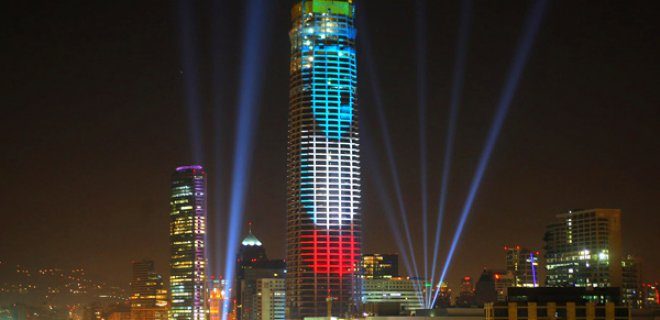
Santiago’s skyline has a new anchor. It is not a cathedral or a colonial square. It’s a trio of skyscrapers that dominate the northern sector as glass monoliths. This is the Costanera Center, a complex so huge it feels like a city in itself.
Designed by the famous architect Cesar Pelli, the towers rise 300 meters into the sky. This height is not just for show. This makes these buildings the tallest in Latin America and the second tallest in the entire Southern Hemisphere. You can see them from afar, a shimmering reminder of how fast Santiago has grown in recent years.
Inside, it’s a completely different beast. Yes, it’s a mall. Huge, divided into six levels. But it’s also a focal point for everything else you need without leaving the building. There are restaurants from fast food to fine dining. A sports center for those who want to burn calories. A movie theater if you want to escape the Andean sun for a few hours. It is modern, stylish and undeniably efficient.
But why do you come here? Because it is the symbol of the new Chile. It is clean, safe and loud with commerce. It shows you the face of a country that wants to be seen as a global player. You walk through the atrium, past the shops and realize that this place is only recently built, but already feels like a landmark. It’s the kind of place you visit to understand where Santiago is going, rather than where it came from.
### Cerro San Cristobal
After the sterile efficiency of the mall, you need air. Real air. Not the recycled kind. You need to escape the grid for a while. This is where Cerro San Cristobal comes into play.
It’s a hill. A real one covered in trees and earth, rising in the midst of urban sprawl. It was a sacred place for the indigenous people for centuries. Now it’s the city’s living room.
You can drive up. You can take the funicular, a historic cable car that rattles and climbs with rhythmic charm. Or you can hike. The hike is steep, but the views are worth every sweaty step.
Once at the top, you stand on a plateau with a 360-degree panorama of Santiago. The city stretches below you, a grid of gray and green bathed in the light of the Andes. In the east, the Andes rise like a wall of snow, sharp and majestic. To the west, the hills disappear into the mist. It’s a view that changes with the time of day. The morning is clear and blue. The sunset bathes the mountains in gold and purple.
There is also a statue. The Virgin of Mount Carmel, a huge white figure who guards the city. It might be a little cheesy. But it’s iconic. You’ll see it on every postcard, brochure and gift shop. It is the spiritual heart of the hill, although the crowds are mostly tourists and locals looking for a picnic spot.
The park itself is lush. There are paths that wind through the trees. Small streams trickling over the rocks. It feels like another world
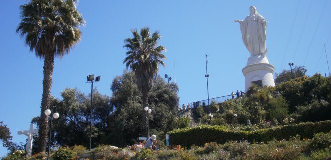
Climbing Cerro San Cristobal
You are standing in the northern quarter of the capital and look up. The height is 880 meters. This puts Cerro San Cristobal a close second in elevation in Santiago, behind only Cerro Renca. It is not the absolute peak, but it’s what defines the view.
The hill is full of telescopes. Several observatories line the hillsides, focusing their lenses on the stars or, more likely, travelers trying to figure out where they are. But the real anchor here is the statue. The Virgin Mary is 22 meters tall. She dominates the skyline. People come looking for panoramic views of the city. They come to view the city from above, making the chaos seem manageable.
Don’t miss this stop. It is one of the must see places in Chile. The air is thinner here. Light hits the Andes differently. You have to see the statue against the backdrop of the mountains to understand why the locals love this place.
Santiago Metropolitan Park
The park stretches around the base of the hill. It is the green lung of the city. Walking here feels like leaving the concrete grid and entering a new century. Paths wind through native trees and manicured gardens. It’s easy to spend half a day wandering here. The connection between the park and the hill is seamless. You start at the bottom, breathe in the smell of pine and continue upwards.
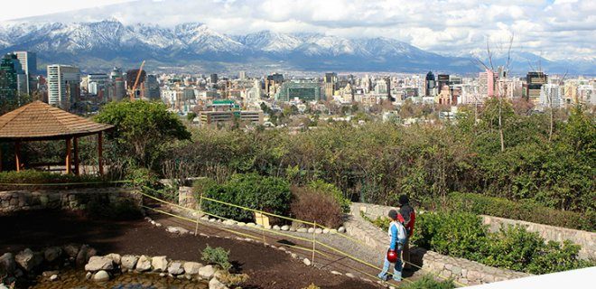
The Green Lung of Santiago: Parque Metropolitano
Santiago’s skyline is more than just steel and concrete. Behind it is a giant green lung that locals and tourists rely on to breathe. We are talking about the Santiago Metropolitan Park, a gigantic urban park that dominates the geography of the city like the Andes dominating the skyline.
It’s more than just a pretty face. This is an important property managed by the Ministry of Housing and Urban Development (MINVU). When asked which city park in South America is worth the trek, this is usually the answer. It is one of the largest urban parks in the world, with an area of 722 hectares. This is not a typo. For comparison, New York’s Central Park covers an area of about 340 hectares. You are looking at more than double the space.
The park opened to the public in 1966, but the land itself retains an old-world feel. There are over 100,000 trees here. You can go hiking. You can bike it. The trails range from easy strolls to steep climbs that can strain your calves if you’re not prepared.
“This is the backyard of the city. If you’re in Santiago and you aren’t going up to the Cristo Redentor statue, you’re missing the blueprint of the city.”
Logistics: Getting There and What to See
You don’t need a car to get to the park. If traveling by metro, get off at Estación San Pedro station (line 3), which is a short walk from the entrance. Once inside, you have two main options for getting around. Either on foot or by cable car (Teleferico).
The cable car is iconic. Connect visitors from the base of the mountain to the top in minutes. The trip itself offers panoramic views of Santiago that change dramatically with the time of day. Come at sunset, and the city turns gold. At night, the light grid below looks like a circuit board.
At the top is a statue of Christ the Redeemer. It stands 14 meters tall and overlooks the entire Central Valley. Most people travel for the scenery. It’s concrete, yes, but it’s worth seeing. The statue was a gift from the United States in 1908 to commemorate the 100th anniversary of Chile’s first democratic elections. It’s a piece of history that doubles as a viewpoint.
Practical tips for your visit:
* Best time to go: Late afternoon. You stayed to beat the heat of the day and watch the light show at dusk.
* Price: Admission is free. The cost of the cable car is around 4,000-5,000 CLP (Chilean pesos) for a round trip, depending on current rates.
What to bring: Water. It gets dry and windy up top. Good walking shoes. The road is paved, but can be uneven in places.
This park is a reminder that urban planning can put nature first. In a country surrounded by mountains and prone to earthquakes, creating this buffer zone is not only aesthetically pleasing, but also practical. Filter the air. It makes the city cooler. What we offer residents
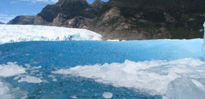
The San Rafael Glacier is one of the huge ice fields that dominate Chile’s northern Patagonia. It is not only a charming place; It’s a geological force that covers a whopping 760 square kilometers in Laguna San Rafael National Park. The sheer scale is hard to grasp until you stand on the beach.
The landscape here is unstable. During the Southern Hemisphere winter, the glacier appears as a bare, frozen monolith. But change the season. Spring and summer bring a dramatic change. The ice melts, causing the water level to rise significantly. This inflow of meltwater feeds the lagoon and changes the local ecosystem overnight.
For all Chile itineraries, the San Rafael Glacier is non-negotiable. It represents one of the country’s most significant natural wonders. You go there to see the ice moving, breaking and entering the sea.
How to see a glacier and why timing is important
You can’t walk over this glacier. It is too active, too dangerous. Instead, you visit by boat by boat or plane. The primary method is a boat trip from the small coastal town of Caleta Tortel or Puerto Chacabuco. These tours take you into the lagoon all the way to the glacier wall.
The view varies depending on when you go there. In winter, the days are short, but the light can be fresh. In summer, the days are long. Melting is visible. You are watching the ice calving in real time. Big pieces come off and fall into the water. The sound is like thunder.
Why is this important to your plan? Because meltwater creates a unique environment. The water is cold, often full of icebergs. The animal world is also changing. Penguins, sea lions and various seabirds gather at the place where the nutrient-rich water meets the ice.
What is the best way to visit San Rafael?
Which option is right for you depends on your budget and tolerance for rough seas. Boat trips are more common and usually cheaper. They offer a closer look at the ice wall. You can see the structure of the ice, the blue tones, the cracks.
Sightseeing tours are an alternative. They offer a bird’s eye view. You can see the whole glacier, the surrounding mountains, the fjords. From above, it’s stunning. But it is more expensive. You spend less time on the site. You fly over it.
Most travelers choose a boat. It’s more immersive. You are in the water. You feel a cold spray. You see scale from a human perspective. Boat trips usually last a few hours. They include stops near smaller icebergs. Guides often point out wildlife. Have your camera ready. The light changes quickly.
Logistics and costs
Getting to the park is part of the adventure. Northern Patagonia is remote. You usually fly to Puerto Montt or the island of Chiloé. It’s a long bus ride from there. The roads are winding. They cross the mountains and descend into the fjords.
Accommodation options are limited. Caleta Tortel is a village with wooden stilt houses. It is charming but simple. Prices vary. Demand increases during the high season. Book in advance. The cost of boat trips varies from reasonable to high, depending on the operator and the duration. Expect to spend the whole day here.
Park entrance
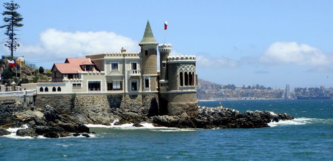
The structure towering over the coast of Viña del Mar is not just another seaside mansion. It’s a heavy, rocky reminder of a colonial obsession, built by someone who apparently wanted to show off their mastery of the waves.
This is Castillo Wulff.
It sits on a 1,260 square meter lot, and the footprint seems small in a building with such a big ego. The construction schedule is chaotic, stretching from 1881 to 1904. That’s 23 years of digging, hauling, and arguing with local workers.
The client was Gustavo Wulff, a German coal merchant who had more money than patience. He didn’t build it for heat. He built it to scare.
In 1908, the scaffolding was dismantled and the doors opened for living. But the building didn’t feel like home until a decade later. In 1917, the architect Alberto Cruz Montt entered. He took the raw structure and dressed it in the perfect castle aesthetic.
Neo-Gothic change
Montt didn’t just add turrets. He reinvented the whole soul of the place.
You will see the result today. A neo-Gothic fortress that looks like it fell out of a Richard Wagner opera and landed on the coast of Chile. The design includes:
- Sharp arcs cutting into the sky
- Iron Gates that look like they belong in a medieval dungeon
- towers that serve no other purpose than to make the skyline more dramatic
- Stone facades that have withstood more than a century of salty air
Why is this important to your travel plan? Because most coastal houses in Viña del Mar are modern, full of glass and forgettable. Castillo Wulff is the opposite. It is dense. It is textured. It needs your attention.
How to visit and what you will see
You can’t just walk in off the street. The castle is a protected building.
In 1995, with a new law, Castillo Wulff was added to the list of National Monuments of Chile. This is not just a plaque on the wall. This means that the structure is recognized as a key part of the country’s cultural heritage. The government is stepping in to make sure the stones stay where they are and history isn’t paved over for a parking lot.
For travelers, this status changes everything. It means:
- The site is officially maintained
- Access is regulated to maintain integrity
- The area is probably part of a protection zone
If you are planning a trip, look for guided tours. They usually leave from nearby Plaza Vergara or Costanera. The view from the castle back over the city is a real reward. You’ll get a sense of how a German merchant sought to claim the landscape as his own, and how Chile has since reclaimed it as public history.
The coal trader’s legacy
Wulff worked in the coal industry. This industry powered ships. It powered cities. It also left a carbon footprint that lasted long after the furnaces went cold.
His decision to build a castle in South America may seem eccentric